Facilities
  OHVs
OHVs Terrain
 Signage
 Emergencies Facilities
 There are no facilities. Hanksville is the closest town for facilities.
OHVsThis trail is suitable for all OHVs.
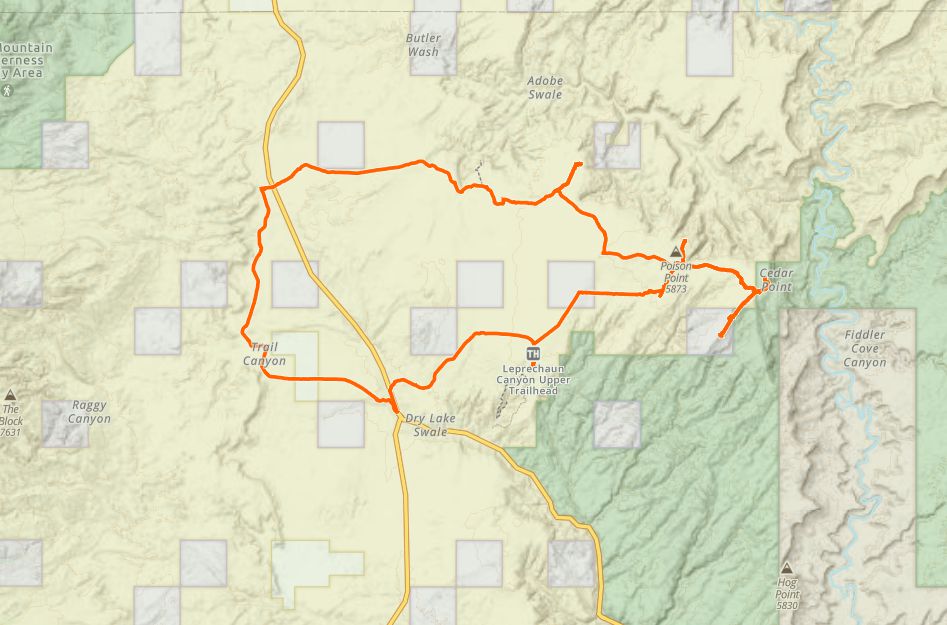
TerrainMostly Sandy trails with occasional rocky patches. There are no difficult obstacles, only beautiful scenery.
SignageThere is some signage at the Little Egypt trail head and carsonite signs marking the trails.
EmergenciesClosest medical facilities Richfield (111 miles), Price (114 miles), Moab (108 miles). Utah Highway Patrol: Dial 9-1-1. We highly recommend you purchase a Utah Search and Rescue Assistant Card (USARA), learn more: utah.gov/rescue.
NATIONAL PARK SERVICES: General Information: 928.608.6200 Bullfrog Ranger Station: (435) 684.7400 Emergency: (928) 608-6300 Emergency: (800) 582-4351.
Garfield Sheriff’s Office Search and Rescue • (435) 676-2678.
Emergencies: Wayne County Sheriff • (435) 836-1308.
NATIONAL PARK SERVICES: General Information: 928.608.6200 Bullfrog Ranger Station: (435) 684.7400 Emergency: (928) 608-6300 Emergency: (800) 582-4351.
Garfield Sheriff’s Office Search and Rescue • (435) 676-2678.
Emergencies: Wayne County Sheriff • (435) 836-1308.
There are no facilities. Hanksville is the closest town for facilities.
This trail is suitable for all OHVs.
Mostly Sandy trails with occasional rocky patches. There are no difficult obstacles, only beautiful scenery.
There is some signage at the Little Egypt trail head and carsonite signs marking the trails.
Closest medical facilities Richfield (111 miles), Price (114 miles), Moab (108 miles). Utah Highway Patrol: Dial 9-1-1. We highly recommend you purchase a Utah Search and Rescue Assistant Card (USARA), learn more: utah.gov/rescue.
NATIONAL PARK SERVICES: General Information: 928.608.6200 Bullfrog Ranger Station: (435) 684.7400 Emergency: (928) 608-6300 Emergency: (800) 582-4351.
Garfield Sheriff’s Office Search and Rescue • (435) 676-2678.
Emergencies: Wayne County Sheriff • (435) 836-1308.
NATIONAL PARK SERVICES: General Information: 928.608.6200 Bullfrog Ranger Station: (435) 684.7400 Emergency: (928) 608-6300 Emergency: (800) 582-4351.
Garfield Sheriff’s Office Search and Rescue • (435) 676-2678.
Emergencies: Wayne County Sheriff • (435) 836-1308.