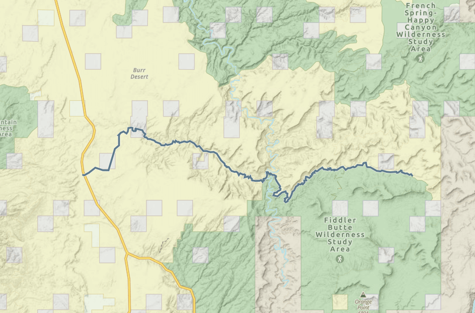
Poison Spring to The Big Ridge

Trail information

Moderate

Out & Back

No width limit

Dirt Trail

Sand Trail

Single Track

50" Vehicle

S x S

Full Size

0 hrs
Moving Time
0 mph
Avg Speed
0 mi
Distance
0 ft
Ascent
0 ft
Descent
No Facilities on the trail. Fuel, food and lodging in nearby Hanksville.
ATVs, MCs, UTVs, High Clearance 4x4s on most trails. Riding is restricted to designated trails. Street-legal OHVs required if driving on trails in the Glen Canyon National Recreation Area.
Sandy backcountry trail, water crossing, steep grades.
BLM Route Markers and Carsonites / well-marked.
Closest medical facilities Richfield (111 miles), Price (114 miles), Moab (108 miles). Utah Highway Patrol: Dial 9-1-1. We highly recommend you purchase a Utah Search and Rescue Assistant Card (USARA), learn more: utah.gov/rescue.
NATIONAL PARK SERVICES: General Information: 928.608.6200 Bullfrog Ranger Station: (435) 684.7400 Emergency: (928) 608-6300 Emergency: (800) 582-4351.
Garfield Sheriff’s Office Search and Rescue • (435) 676-2678.
Emergencies: Wayne County Sheriff • (435) 836-1308.
The Poison Spring OHV trail will take you on a remote desert drive crossing the Dirty Devil and riding among buttes and canyons that are hard to describe with words or pictures. We hope this will give you a good preview of a great trail for experienced riders, and we would strongly suggest taking some friends along and letting those at home know where you are going. Walking out of this area really isn’t an option, and it is remote.

Butch Cassidy is said to have hid out here among the remote canyons and red rocks in addition to the indigenous people who made these canyons their homes. Please respect the trails and any artifacts you may come across. Please also note the trail follows the Fiddler Butte Wilderness Study Area boundary just before you cross the Dirty Devil (that boundary also happens to run along the bench of the trail with a steep drop off so staying on the road is highly encouraged).

Basing out of Hanksville, Utah (17 miles from the trailhead) allows for close access to the trailhead to get an early start on the trail without a lot of additional travel. We spent six hours riding the trail for 70 miles at approximately 12 mph. You will want to plan on a long day out to allow for plenty of time for getting back. We rode the trail as an out and back, but there are trails in the area that will take you all the way back to highway 95 at Hite near Lake Powell (you will need a street-legal machine to ride within the boundaries of the Glen Canyon National Recreation Area). You can shorten the trip by turning around at the Dirty Devil or the Dirty Devil may turn you around which still makes for five hours of fantastic riding.
Maps

Trail Route

poison spring gaia

We recommend to download the GAIA App on your mobile device.

You can view and download the route from GAIA as well as see photos with their location geotagged on the trail.

360 Street View

Click “View 360 Map” to explore the trail in Google Street View and “See the Trail Before You Ride the Trail.”

Flyover Map

 Experience a bird’s-eye view of the trail to get a better understanding of elevation changes and the surrounding terrain.

Time Lapse

Download Route

The GPX or KML files are available for you to download and use on your preferred app or device. 

Key Points

Within our Key Points you will discover trail head parking, trail markers, points of interests, intersections as well as terrain and obstacles.

Click on the links below to reveal images and information

The trail begins right off Highway 95 on BLM Route 15210. Turn left to head north on BLM 15015. BLM 15015 runs into 15000, turn right to head east where you will drop into Poison Spring Canyon.
Keep right to continue heading southeast down the canyon.
This is a good example of where the canyon opens up. Pay close attention to the weather before heading out this is a bad place to be if a flash flood comes through.
Generally this trail is a sandy trail through the bottom of the canyon until you cross at the Dirty Devil.
Cottonwoods or canyon walls may supply a little respite from the sun and a quiet place to listen to the canyon. Some spring foliage will really pop off the sunburned rock walls of the canyon. Keep a sharp eye and you may see petroglyphs and signs of previous visitors of the canyon (including the infamous Butch Cassidy). Please respect all archeology and be aware that includes artifacts that are as recent as 50 years ago.
Stay right of the BLM 12020 route marker to head east toward the Dirty Devil. The spur to the left will climb into the benches of the canyon and appears to deadend overlooking Happy Canyon above the Dirty Devil.
You will cross a cattleguard near this spot where we stopped to contemplate just how small we are among the grandness of the surrounding desert. This would be a good place to take a break if you are in a larger group.
Dirty Devil Crossing. Make sure you have a good idea of how deep the river and how much water is flowing. This is a good place to turn around if you want to cut the trip in half *or if the river is higher than anticipated.
This is where you will begin seeing trail markers for Poison Spring Route 1.
Overlooking the Dirty Devil
The road is pretty good overall but there may be segments that get washed out and you’ll want to hug the inside of the road if you’re afraid of heights. Grand views as you climb out of the canyon into the benches.
Weaving in and out along the benches below the buttes.
While this isn’t a beginner ride it is a pretty good trail.
This is where we turned around to make the trail an out and back. However, continuing on you can explore The Big Ridge and Sunset Pass. We will be uploading those tracks and 360 views in the near future. Parts of those trails will show up in Google Street View now if you wish to explore. There is a way to take this trail in and come out again on Highway 95 near Hite at Lake Powell.
trail video
Share The Trail
Facebook
Twitter
LinkedIn
Email
WhatsApp
comments
0.0
Rated 0.0 out of 5
0.0 out of 5 stars (based on 0 reviews)
Excellent0%
Very good0%
Average0%
Below Average0%
Poor0%

There are no comments yet be the first to write one :)

Related Trails

We add new trails every week!

Receive the latest trails, as well as updates on outdoor recreation and off-road events in Utah.
Join our community!

small_c_popup.png

Thank You For Joining Outsiders!!