Facilities
  OHVs
OHVs Terrain
 Signage
 Emergencies Facilities
 The Trail head at Ticaboo can provide most anything you may need. Food, Fuel, lodging.
OHVsAl OHVs are suitable for this trail.
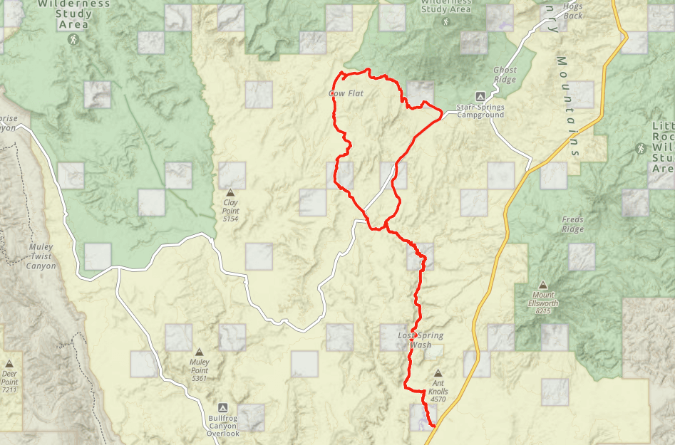
TerrainMostly grade roads. Some sand washes and rocky areas. Some canyon trail may be washed out depending on when you arrive.
You should inquire in Ticaboo if there are any limitations or washouts. This trail is suitable for most riders or all abilities.
You should inquire in Ticaboo if there are any limitations or washouts. This trail is suitable for most riders or all abilities.
SignageThere is a Kiosk in Ticaboo and carsonite signs along the trail.
EmergenciesClosest medical facilities Richfield (111 miles), Price (114 miles), Moab (108 miles). Utah Highway Patrol: Dial 9-1-1. We highly recommend you purchase a Utah Search and Rescue Assistant Card (USARA), learn more: utah.gov/rescue.
NATIONAL PARK SERVICES: General Information: 928.608.6200 Bullfrog Ranger Station: (435) 684.7400 Emergency: (928) 608-6300 Emergency: (800) 582-4351.
Garfield Sheriff’s Office Search and Rescue • (435) 676-2678.
NATIONAL PARK SERVICES: General Information: 928.608.6200 Bullfrog Ranger Station: (435) 684.7400 Emergency: (928) 608-6300 Emergency: (800) 582-4351.
Garfield Sheriff’s Office Search and Rescue • (435) 676-2678.
The Trail head at Ticaboo can provide most anything you may need. Food, Fuel, lodging.
Al OHVs are suitable for this trail.
Mostly grade roads. Some sand washes and rocky areas. Some canyon trail may be washed out depending on when you arrive.
You should inquire in Ticaboo if there are any limitations or washouts. This trail is suitable for most riders or all abilities.
You should inquire in Ticaboo if there are any limitations or washouts. This trail is suitable for most riders or all abilities.
There is a Kiosk in Ticaboo and carsonite signs along the trail.
Closest medical facilities Richfield (111 miles), Price (114 miles), Moab (108 miles). Utah Highway Patrol: Dial 9-1-1. We highly recommend you purchase a Utah Search and Rescue Assistant Card (USARA), learn more: utah.gov/rescue.
NATIONAL PARK SERVICES: General Information: 928.608.6200 Bullfrog Ranger Station: (435) 684.7400 Emergency: (928) 608-6300 Emergency: (800) 582-4351.
Garfield Sheriff’s Office Search and Rescue • (435) 676-2678.
NATIONAL PARK SERVICES: General Information: 928.608.6200 Bullfrog Ranger Station: (435) 684.7400 Emergency: (928) 608-6300 Emergency: (800) 582-4351.
Garfield Sheriff’s Office Search and Rescue • (435) 676-2678.