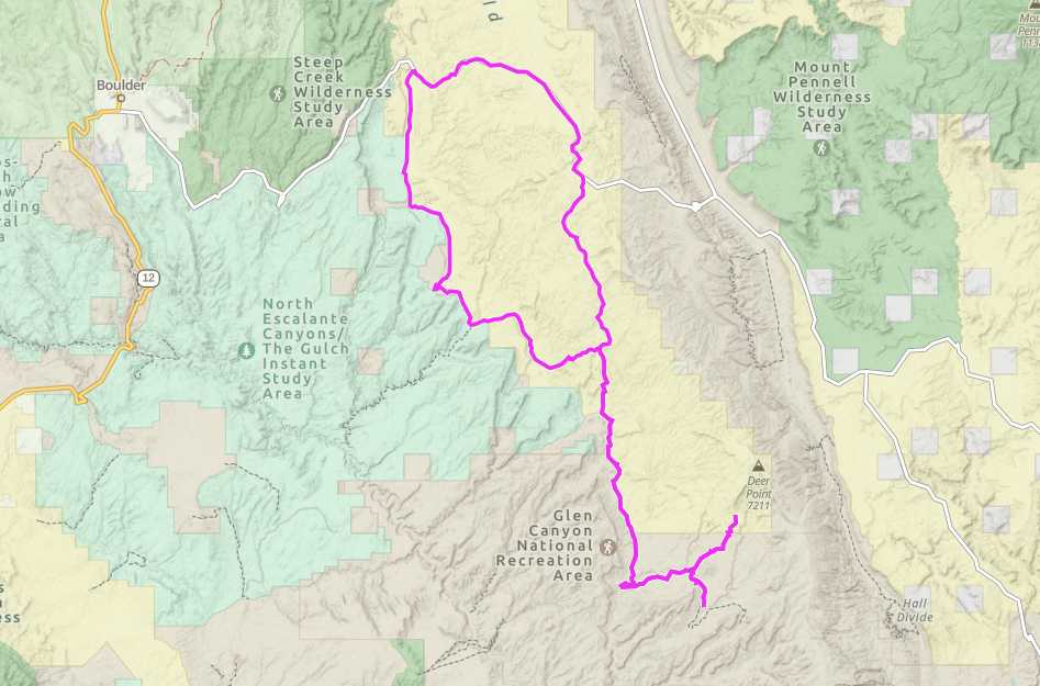
Wolverine Moody Loop

Trail information

Easy

Loop Trail

No width limit

Dirt Trail

Paved Roads

Single Track

50" Vehicle

S x S

Full Size

0 hrs
Moving Time
0 mph
Avg Speed
0 mi
Distance
0 ft
Ascent
0 ft
Descent
Closest lodging, restaurants, gas is in Boulder, UT. More amenities can be found in Escalante, Torrey, or Ticaboo. The trail is very remote with no services. You can camp in BLM portions of the trail.
All sizes. No width limits. ATVs, MCs, UTVs, 4x4s on most trails.
Well maintained dirt roads. Paved road on Burr Trail Road.
Trail is well signed and areas of interest are noted.
Garfield Memorial Hospital. 200 N 400 E St, Panguitch, UT 84759. Emergency room open 24 hours a day.
Garfield County Sheriff: Dial 9-1-1 for emergencies or Non-Emergency Dispatch: 435-676-2678; Utah Highway Patrol: Dial 9-1-1.
We highly recommend you purchase a Utah Search and Rescue Assistant Card (USARA) learn more: utah.gov/rescue
Do you ever feel that desire to go ride somewhere way out in the sticks? The kind of place you are unlikely to encounter another human? To go enjoy the West like it might have felt to a lone rider on horseback traversing a great wild land?

A place like that exists, East of Boulder Utah, South of Capitol Reef NP, and North West of Lake Powell.

The Wolverine Moody Loop is a beginner level loop trail with an optional out and back section along the Moody Creek Road. The whole trip is 77 miles long and will be an all day event lasting between five to six hours.

The trailhead is located about 19 miles east of the town of Boulder (37.92, -111.22). Staging and camping can be done on wide pull outs once you exit the paved Burr Trail road. Even large rigs that venture out this way will find a place to park or camp that wont give you too much trouble. The trail features scrubby red desert and beautiful red rock ledges and canyons.

Most of the terrain is a well maintained dirt road, but there may be sandy washes to traverse at certain points. This is a very remote area that you can get to easily thanks to the quality of the roads.

One of the unique aspects of this trail is the amount of petrified wood and petrified forests that exist along the loop. You can read about one of the many locations here: learn more.

The closest town is Boulder, which has some lodging and restaurants, but for more amenities and supplies you can visit Escalante to the west, Torrey to the north (though Notom Road may rattle your teeth loose) or Ticaboo to the east.

Safety wise – this area of the state gets very hot, so make sure you bring more water than you need, and pay attention to the weather to avoid flash floods.
Maps

Trail Route

Wolverine Moody Loop gaia

We recommend to download the GAIA App on your mobile device.

You can view and download the route from GAIA as well as see photos with their location geotagged on the trail.

360 Street View

Click “View 360 Map” to explore the trail in Google Street View and “See the Trail Before You Ride the Trail.”

Time Lapse

Download Route

The GPX or KML files are available for you to download and use on your preferred app or device. 

Key Points

Within our Key Points you will discover trail head parking, trail markers, points of interests, intersections as well as terrain and obstacles.

Click on the links below to reveal images and information

This is the turn off from the Burr Trail Road to the Wolverine Loop. You can stage off this road down about 500 feet or so.
The road is quite good for the most part. As you can see here its a smooth one so you will make good time. This section follows the ledges that run North-South along the West side of the trail.
About 10 miles into the trail you’ll see a stopping point and sign for Wolverine Canyon Petrified Wood Natural Area. This is a fun moment to stretch your legs and see some amazing petrified wood specimens. Please note: Collecting samples is this area is prohibited.
Twenty miles in you will reach the junction for the Wolverine Loop and Moody Canyons. Turning right will take you on an out and back adventure adding 40 miles total. Go left to complete the loop.

If you choose to to do the Moody Canyon portion, be aware that it enters Glen Canyon National Recreation Area property.
The trail also runs adjacent to several Wilderness Study Areas, so keep eyes out for signs and stay on the trail!

You will pass the old Colt Mesa Copper Mine and follow Choprock Bench (on the right in this 360)
Left or right? Either is fine. The Left , Purple Hill sroad, will take you out to a dead end but the trail is fun and not to long, about a mile or so. The road on the right eventually dead ends looking down into the far reaching edges of tributaries to Escalante River and lake Powell. You are a very long way from anywhere here so be careful and embrace the felling of solitude. Feel free to explore.
To complete the loop,return the way you came except don’t go cak toward Wolverine canyon. Simply continue due North, the road is in great shape. Soon you can get back on to the Burr Trail Road and drive 10 miles west back to the staging area.
trail video

Coming Soon!

Share The Trail
Facebook
Twitter
LinkedIn
Email
WhatsApp
comments
0.0
Rated 0.0 out of 5
0.0 out of 5 stars (based on 0 reviews)
Excellent0%
Very good0%
Average0%
Below Average0%
Poor0%

There are no comments yet be the first to write one :)

Related Trails

We add new trails every week!

Receive the latest trails, as well as updates on outdoor recreation and off-road events in Utah.
Join our community!

small_c_popup.png

Thank You For Joining Outsiders!!