Facilities
  OHVs
OHVs Terrain
 Signage
 Emergencies Facilities
 No Facilities on the trail. Fuel, food and lodging in Joseph or nearby Richfield, Utah
OHVs ** Some areas restricted to 60″** ATVs, MCs, UTVs. High clearance 4x4s on most trails. Riding is restricted to designated trails.
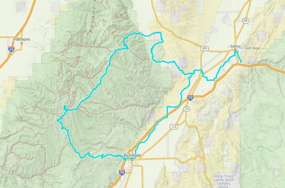
TerrainDirt backcountry road as well as paved road.
SignageTrail is well signed.
EmergenciesSevier Valley Medical Center, (Intermountain Healthcare) 1000 North Main Street, Richfield, UT 84701 (435) 893-4100
Sevier County Sheriff: Dial 9-1-1 or (435) 896-2600; Utah Highway Patrol – Richfield: Dial 9-1-1 or (435) 896-2780.
We highly recommend you purchase a Utah Search and Rescue Assistant Card (USARA), learn more: utah.gov/rescue
Sevier County Sheriff: Dial 9-1-1 or (435) 896-2600; Utah Highway Patrol – Richfield: Dial 9-1-1 or (435) 896-2780.
We highly recommend you purchase a Utah Search and Rescue Assistant Card (USARA), learn more: utah.gov/rescue
No Facilities on the trail. Fuel, food and lodging in Joseph or nearby Richfield, Utah
** Some areas restricted to 60″** ATVs, MCs, UTVs. High clearance 4x4s on most trails. Riding is restricted to designated trails.
Dirt backcountry road as well as paved road.
Trail is well signed.
Sevier Valley Medical Center, (Intermountain Healthcare) 1000 North Main Street, Richfield, UT 84701 (435) 893-4100
Sevier County Sheriff: Dial 9-1-1 or (435) 896-2600; Utah Highway Patrol – Richfield: Dial 9-1-1 or (435) 896-2780.
We highly recommend you purchase a Utah Search and Rescue Assistant Card (USARA), learn more: utah.gov/rescue
Sevier County Sheriff: Dial 9-1-1 or (435) 896-2600; Utah Highway Patrol – Richfield: Dial 9-1-1 or (435) 896-2780.
We highly recommend you purchase a Utah Search and Rescue Assistant Card (USARA), learn more: utah.gov/rescue