Facilities
  OHVs
OHVs Terrain
 Signage
 Emergencies Facilities
 There are a variety of options for lodging, camping, restaurants, fuel and groceries in Kanab 30 miles from the trailhead. Other nearby communities include Glendale, Orderville and Mt. Carmel Junction. There are no services along the Skutumpah Road. Tropic has places to stay the night, some restaurants, groceries and fuel.
OHVsAll sizes. No width limits. ATVs, MCs, UTVs, 4x4s on most trails.
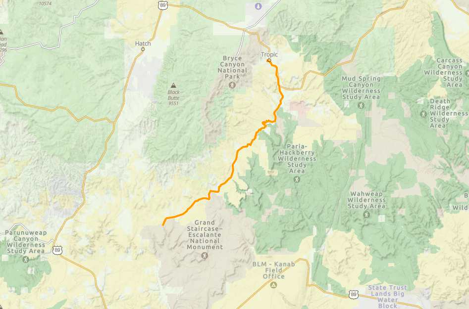
TerrainMaintained county road.
SignageTrail is well signed.
EmergenciesGarfield Memorial Hospital 200 N 400 E Panguitch, UT 84759 (435) 676-8811
Kane County Sheriff: Dial 9-1-1 for emergencies or Non-Emergency Dispatch: (435) 644-2349; Garfield County Sheriff: Dial 9-1-1 for emergencies or Non-Emergency (435) 676-2678.
We highly recommend you purchase a Utah Search and Rescue Assistant Card (USARA) learn more: utah.gov/rescue
Kane County Sheriff: Dial 9-1-1 for emergencies or Non-Emergency Dispatch: (435) 644-2349; Garfield County Sheriff: Dial 9-1-1 for emergencies or Non-Emergency (435) 676-2678.
We highly recommend you purchase a Utah Search and Rescue Assistant Card (USARA) learn more: utah.gov/rescue
There are a variety of options for lodging, camping, restaurants, fuel and groceries in Kanab 30 miles from the trailhead. Other nearby communities include Glendale, Orderville and Mt. Carmel Junction. There are no services along the Skutumpah Road. Tropic has places to stay the night, some restaurants, groceries and fuel.
All sizes. No width limits. ATVs, MCs, UTVs, 4x4s on most trails.
Maintained county road.
Trail is well signed.
Garfield Memorial Hospital 200 N 400 E Panguitch, UT 84759 (435) 676-8811
Kane County Sheriff: Dial 9-1-1 for emergencies or Non-Emergency Dispatch: (435) 644-2349; Garfield County Sheriff: Dial 9-1-1 for emergencies or Non-Emergency (435) 676-2678.
We highly recommend you purchase a Utah Search and Rescue Assistant Card (USARA) learn more: utah.gov/rescue
Kane County Sheriff: Dial 9-1-1 for emergencies or Non-Emergency Dispatch: (435) 644-2349; Garfield County Sheriff: Dial 9-1-1 for emergencies or Non-Emergency (435) 676-2678.
We highly recommend you purchase a Utah Search and Rescue Assistant Card (USARA) learn more: utah.gov/rescue