Facilities
  OHVs
OHVs Terrain
 Signage
 Emergencies Facilities
 No Facilities on the trail. Fuel, food and lodging in Joseph or nearby Richfield, Utah
OHVsATVs, MCs, UTVs, High clearance 4x4s on most trails. Riding is restricted to designated trails.
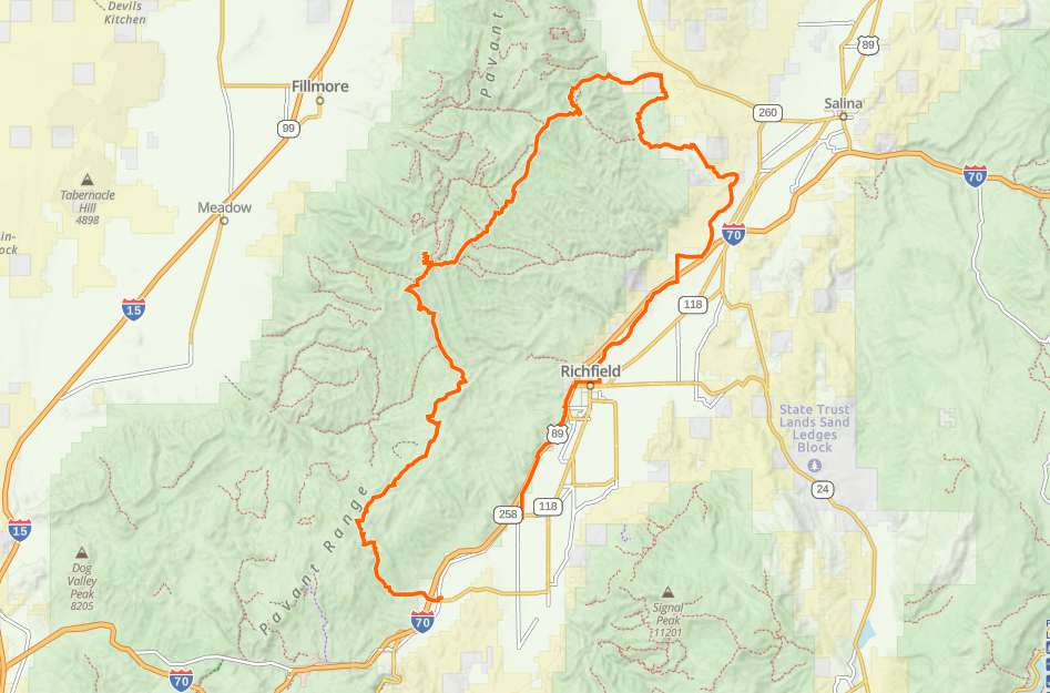
TerrainDirt backcountry roads and paved roads through town
SignageBLM Route Markers and Carsonites / well-marked
EmergenciesSevier Valley Hospital • 1000 N Main St, Richfield, UT 84701 • (435) 893-4100; Dial 9-1-1 for emergencies
Sheriff: Sevier County Sheriff: Dial 9-1-1 for emergencies or non-emergency dispatch: (435) 893-4100
We highly recommend you purchase a Utah Search and Rescue Assistant Card (USARA)
Sheriff: Sevier County Sheriff: Dial 9-1-1 for emergencies or non-emergency dispatch: (435) 893-4100
We highly recommend you purchase a Utah Search and Rescue Assistant Card (USARA)
No Facilities on the trail. Fuel, food and lodging in Joseph or nearby Richfield, Utah
ATVs, MCs, UTVs, High clearance 4x4s on most trails. Riding is restricted to designated trails.
Dirt backcountry roads and paved roads through town
BLM Route Markers and Carsonites / well-marked
Sevier Valley Hospital • 1000 N Main St, Richfield, UT 84701 • (435) 893-4100; Dial 9-1-1 for emergencies
Sheriff: Sevier County Sheriff: Dial 9-1-1 for emergencies or non-emergency dispatch: (435) 893-4100
We highly recommend you purchase a Utah Search and Rescue Assistant Card (USARA)
Sheriff: Sevier County Sheriff: Dial 9-1-1 for emergencies or non-emergency dispatch: (435) 893-4100
We highly recommend you purchase a Utah Search and Rescue Assistant Card (USARA)