Stud Horse Draw

Trail information

Easy

Loop Trail

No width limit

Dirt Trail

gravel roads

Single Track

50" Vehicle

S x S

Full Size

0 hrs
Moving Time
0 mph
Avg Speed
0 mi
Distance
0 ft
Ascent
0 ft
Descent
Lodging, restaurants, fuel and groceries are all available in Enterprise. There are no services available along the trail.
All sizes. No width limits. ATVs, MCs, UTVs, 4x4s on most trails.
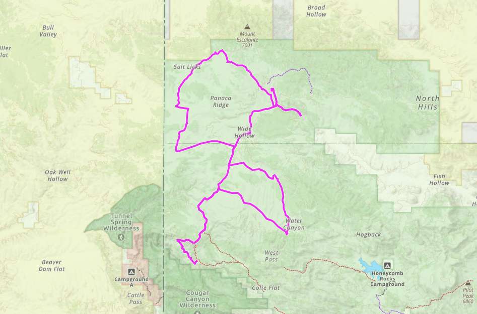
Mostly dirt and gravel roads.
The area is signed fairly well but some of the signs are weathered. Look at our notes below and download a GPS track (see below).
The closest medical help is Enterprise Valley Medical Clinic, 223 S 200 E Street, Enterprise, UT 84725. Dial 9-1-1 for emergencies.
Washington County Sheriff: Dial 9-1-1 or 620 S 5300 W, Hurricane, UT 84737 (435) 656-6500.
We highly recommend you purchase a Utah Search and Rescue Assistant Card (USARA) learn more: utah.gov/rescue
The Stud Horse Draw OHV Loop is a good ride for beginners that lies off the beaten path. The trailhead is 15 miles or so west of Enterprise and offers some unique scenery, riding and a trip back to the Old West. The 50-mile trip took us about 4.5 hours to complete with an average moving speed of 11.5 mph.

Terrain consists of mostly dirt and gravel roads that take off across the flats for some high desert riding. Picnic tables and ponderosa pines make the stop at pine park a good place to have a picnic and take in something different than the junipers and sagebrush.

Enterprise makes a great base-camp offering a small motel, groceries, fuel and a couple eateries. Nearby Enterprise Reservoir and the surrounding area offer great opportunities for camping.

This is a popular ride during the Tristate ATV Jamboree that typically takes place in March. You can find out more about this event and find some great people to ride with by visiting thetristateatvclub.com
Maps

Trail Route

Studhorse Draw gaia compressed

We recommend to download the GAIA App on your mobile device.

You can view and download the route from GAIA as well as see photos with their location geotagged on the trail.

360 Street View

Click “View 360 Map” to explore the trail in Google Street View and “See the Trail Before You Ride the Trail.”

Flyover Map

 Experience a bird’s-eye view of the trail to get a better understanding of elevation changes and the surrounding terrain.

Download Route

The GPX or KML files are available for you to download and use on your preferred app or device. 

Key Points

Within our Key Points you will discover trail head parking, trail markers, points of interests, intersections as well as terrain and obstacles.

Click on the links below to reveal images and information

Head west on the only road through town. This parking area is just off the main road a short ways after the pavement ends (Crestline Rd.)..
You will head back east on the road you came in on (Crestline Road) Turn left to head north on Forest Road 877.
This segment of the trail is easy riding on gravel roads with a couple crossings through wash bottoms.
Riding up this wash will take you to Nephi Spring.
This spur took us to a dead end up in the junipers.
Turn right to head north here onto Forest Road 1014 (the 4 is the only legible number on the sign currently).
Continue on the same route heading west (1014).
Turn right after the cattleguard following the fence line north.
Follow the road straight to continue heading west. This stretch is relatively flat riding through the junipers and sagebrush as you go around Panaca Ridge.
You’ll ride back down Crestline Road again until you come to this turnoff to head onto Forest Road 1007.
You’ll find a change of scenary among the ponderosa pines and white rocks at the Pine Park Campground.
This ride has a lot of high desert riding off the beaten path with open space stretching’s out in every direction. It really is a trip back to the Old West.
trail video
Share The Trail
Facebook
Twitter
LinkedIn
Email
WhatsApp
comments
0.0
Rated 0.0 out of 5
0.0 out of 5 stars (based on 0 reviews)
Excellent0%
Very good0%
Average0%
Below Average0%
Poor0%

There are no comments yet be the first to write one :)

Related Trails

We add new trails every week!

Receive the latest trails, as well as updates on outdoor recreation and off-road events in Utah.
Join our community!

small_c_popup.png

Thank You For Joining Outsiders!!