Facilities
  OHVs
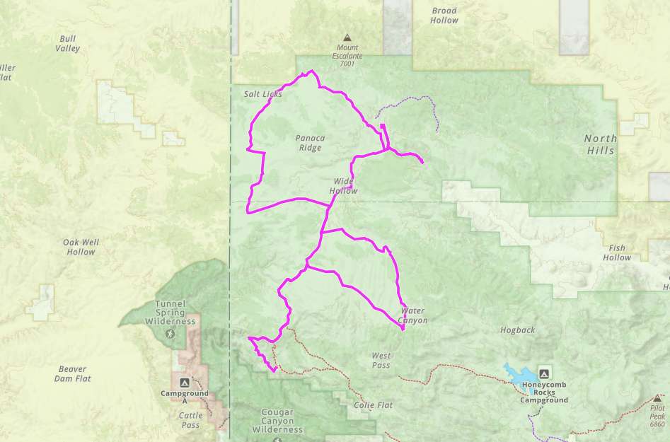
OHVs Terrain
 Signage
 Emergencies Facilities
 Lodging, restaurants, fuel and groceries are all available out of Enterprise to the north. You can also find fuel and supplies on your way to the trailhead in Veyo. The trail is also close to the St. George and Cedar City area.
OHVsAll sizes. No width limits. ATVs, MCs, UTVs, 4x4s on most trails.
TerrainMostly dirt and gravel roads.
SignageThe area is well signed but a GPS is a huge plus.
EmergenciesThe closest medical help is Enterprise Valley Medical Clinic, 223 S 200 E St, Enterprise, UT 84725. Dial 9-1-1 for emergencies.
Washington County Sheriff: Dial 9-1-1 or (435) 656-6500.
We highly recommend you purchase a Utah Search and Rescue Assistant Card (USARA) learn more: utah.gov/rescue
Washington County Sheriff: Dial 9-1-1 or (435) 656-6500.
We highly recommend you purchase a Utah Search and Rescue Assistant Card (USARA) learn more: utah.gov/rescue
Lodging, restaurants, fuel and groceries are all available out of Enterprise to the north. You can also find fuel and supplies on your way to the trailhead in Veyo. The trail is also close to the St. George and Cedar City area.
All sizes. No width limits. ATVs, MCs, UTVs, 4x4s on most trails.
Mostly dirt and gravel roads.
The area is well signed but a GPS is a huge plus.
The closest medical help is Enterprise Valley Medical Clinic, 223 S 200 E St, Enterprise, UT 84725. Dial 9-1-1 for emergencies.
Washington County Sheriff: Dial 9-1-1 or (435) 656-6500.
We highly recommend you purchase a Utah Search and Rescue Assistant Card (USARA) learn more: utah.gov/rescue
Washington County Sheriff: Dial 9-1-1 or (435) 656-6500.
We highly recommend you purchase a Utah Search and Rescue Assistant Card (USARA) learn more: utah.gov/rescue