Facilities
  OHVs
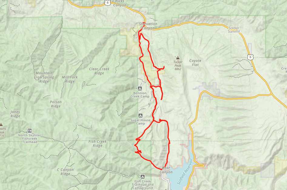
OHVs Terrain
 Signage
 Emergencies Facilities
 Bathrooms and Campsites at Scofield State Park, Fuel in Scofield, we recommend stockingup on additional supplies in Spanish Fork, Mt. Pleasant or Price.
OHVsAll sizes. No width limits. ATVs, MCs, UTVs, 4x4s on most trails.
TerrainThe trail is good for beginners in terms of terrain.
SignageMost trails have adequate signage. Pay attention to areas marked as “no trespassing” or posted as private property.
EmergenciesNearby Medical Castleview Hospital 300 North Hospital Drive Price, UT 84501. (435) 637-4800.
Nearby Medical Sanpete Valley Hospital 1100 S Medical Dr. Mount Pleasant UT 84647. (435) 462-2441.
Scofield State Park: Summer (435) 448-9449 – Winter (435) 687-2491
Carbon County Sheriff: Dial 9-1-1 for emergencies or Non-Emergency Dispatch (435) 636-3251
Utah Highway Patrol: Dial 9-1-1
We highly recommend you purchase a Utah Search and Rescue Assistant Card (USARA) learn more: utah.gov/rescue
Bathrooms and Campsites at Scofield State Park, Fuel in Scofield, we recommend stockingup on additional supplies in Spanish Fork, Mt. Pleasant or Price.
All sizes. No width limits. ATVs, MCs, UTVs, 4x4s on most trails.
The trail is good for beginners in terms of terrain.
Most trails have adequate signage. Pay attention to areas marked as “no trespassing” or posted as private property.
Nearby Medical Castleview Hospital 300 North Hospital Drive Price, UT 84501. (435) 637-4800.
Nearby Medical Sanpete Valley Hospital 1100 S Medical Dr. Mount Pleasant UT 84647. (435) 462-2441.
Scofield State Park: Summer (435) 448-9449 – Winter (435) 687-2491
Carbon County Sheriff: Dial 9-1-1 for emergencies or Non-Emergency Dispatch (435) 636-3251
Utah Highway Patrol: Dial 9-1-1
We highly recommend you purchase a Utah Search and Rescue Assistant Card (USARA) learn more: utah.gov/rescue