Salina to Gooseberry OHV Trail

Trail information

Easy

Loop Trail

No width limit

Dirt Trail

paved roads

Single Track

50" Vehicle

S x S

Full Size

0 hrs
Moving Time
0 mph
Avg Speed
0 mi
Distance
0 ft
Ascent
0 ft
Descent
Lodging, restaurants, fuel and groceries in Salina. Pit toilets and picnic areas are scattered along the trail.
All sizes. No width limits. ATVs, MCs, UTVs, 4x4s on most trails. Most of the trails accommodate any size vehicle.
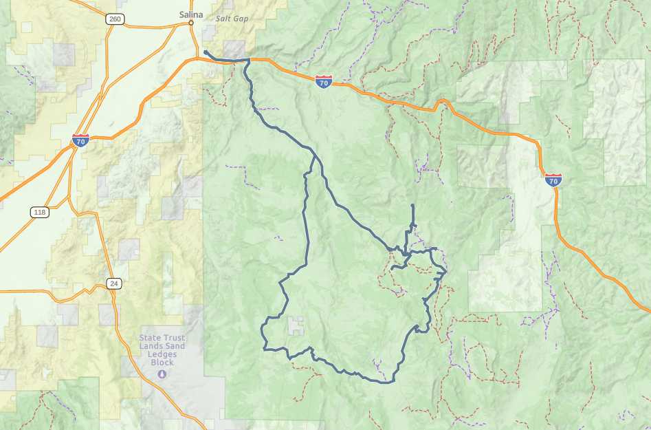
Mostly paved and dirt roads.
Trail is well signed.
Sevier Valley Medical Center (Intermountain Healthcare) 1000 North Main Street, Richfield, UT 84701 (435) 893-4100
Sevier County Sheriff: Dial 9-1-1 or (435) 896-2600; Utah Highway Patrol – Richfield: Dial 9-1-1 or (435) 896-2780.
We highly recommend you purchase a Utah Search and Rescue Assistant Card (USARA), learn more: utah.gov/rescue
The Salina to Gooseberry Loop is a great beginner trail that can accommodate virtually any vehicle. If you want to get off the pavement into some trees you will want to bring a 50″ or smaller machine because there is some great riding in this area that you can access from this route. The entire loop is 70 miles and took us 5.5 hours (moving) to complete. Plan a full day for this ride because there are a number of small ponds and reservoirs to hike around and look at. This is also a good beginner trail because there is a fair amount of pavement and easy dirt roads to ride on.

We started at the Salina City Park and crossed under I-70 to start up the canyon. Nearby Salina has a few restaurants, gas, groceries and some lodging. There is a variety of dispersed and developed camping in the area. If you plan you trip around the annual Eyes to the Sky Balloon Festival (https://eyestotheskyballoonfestival.com/), you will have enough time in the morning to catch the balloons before heading out on the trail to beat the heat in the valley.

The elevation makes this a good summer or early fall ride, especially if you go when the leaves are changing. Fish Lake and Pando are nearby if you continue on Forest Road 640 after you get to the top of the trail.
Maps

Trail Route

Salina to Gooseberry Trail gaia

We recommend to download the GAIA App on your mobile device.

You can view and download the route from GAIA as well as see photos with their location geotagged on the trail.

360 Street View

Click “View 360 Map” to explore the trail in Google Street View and “See the Trail Before You Ride the Trail.”

Flyover Map

 Experience a bird’s-eye view of the trail to get a better understanding of elevation changes and the surrounding terrain.

Download Route

The GPX or KML files are available for you to download and use on your preferred app or device. 

Key Points

Within our Key Points you will discover trail head parking, trail markers, points of interests, intersections as well as terrain and obstacles.

Click on the links below to reveal images and information

There is plenty of parking and a kiosk about the trail near the intersection of Veyo Shoal Creek Road and Bench Road. The trail will take you northwest into the Dixie National Forest and some cooler temperatures.
You will cross under I-70 and head up Soldier Canyon.
Here is another area where you could park to head out on this trail or find access to a pit toilet. This is also the trailhead for the Gooseberry snowmobile complex in the winter.
There are a few of these great pulloffs from the main road that take you into the quakies for a picnic or some camping.
Here’s the view near the top of your ascent on the trail.
The trail does have some pit toilets along the way. This is at the Twin Ponds CUA Dispersed Camping Area. A short way down the road is the Cold Springs CUA Dispersed Camping Area.
You’ve reached the top!
Great views all around with this parking lot to stop and let the rest of the group catch up. We headed toward Cold Spring to the west from here.
As you can see it’s a pretty easy going trail (lots of pavement and some dirt roads).
Follow the sign for Rex Reservoir.
trail video
Share The Trail
Facebook
Twitter
LinkedIn
Email
WhatsApp
comments
0.0
Rated 0.0 out of 5
0.0 out of 5 stars (based on 0 reviews)
Excellent0%
Very good0%
Average0%
Below Average0%
Poor0%

There are no comments yet be the first to write one :)

Related Trails

We add new trails every week!

Receive the latest trails, as well as updates on outdoor recreation and off-road events in Utah.
Join our community!

small_c_popup.png

Thank You For Joining Outsiders!!