Arapeen OHV Trail: Mt. Pleasant Loop

Trail information

Easy

Loop Trail

Dirt Trail

graded roads

Single Track

50" Vehicle

S x S

0 hrs
Moving Time
0 mph
Avg Speed
0 mi
Distance
0 ft
Ascent
0 ft
Descent
Mt. Pleasant offers a great base camp with motels, restaurants and fuel.
*66″ width restriction on one segment of this trail. ATVs, MCs, UTVs, 4x4s on most trails.
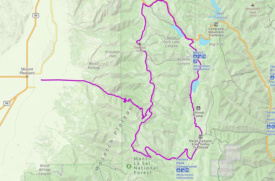
Easy – mostly graded county roads. 4,000 feet of climbing first hour of the ride.
Most trails have adequate signage.
The closest medical help is the Sanpete Valley Hospital, 1100 S Medical Drive, Mt Pleasant, UT 84647. (435) 462-2441

Dial 9-1-1 for emergencies.

Sanpete County Sheriff: Dial 9-1-1 or (435) 835-2191. 1500 S Hwy 89, Manti, UT 84642

Utah Highway Patrol: Dial 9-1-1

We highly recommend you purchase a Utah Search and Rescue Assistant Card (USARA), learn more: gov/rescue
The Mt. Pleasant Loop starts after riding up the canyon outside of Mt. Pleasant on Forest Route 0037 until you come to Skyline Drive. This loop sits between 8,000 and 10,000 feet in elevation making for a great escape from the heat of the summer. We encountered a summer rainstorm and want to remind you that a jacket and some extra gear are helpful when the blue sky begins to turn dark.

Today, we road about 45 miles in 5 hours with an average speed of 10 mph (there is almost 4,000 feet of climbing when you first head out on the trail). Once on top, there are views in every direction. This trail will take you past Huntington and Miller Flat Reservoirs offering some fun stops along the way. We’d suggest you plan the whole day for your ride with a little extra time to find a good malt and a burger in Mt. Pleasant.

The trail is close to Mt. Pleasant where you will find the necessary amenities for a stocking up for a day on the trail as well as places to stay at the end of your day.
Maps

Trail Route

Arapeen OHV Trail Mt Pleasant Loop gaia

We recommend to download the GAIA App on your mobile device.

You can view and download the route from GAIA as well as see photos with their location geotagged on the trail.

360 Street View

Click “View 360 Map” to explore the trail in Google Street View and “See the Trail Before You Ride the Trail.”

Flyover Map

 Experience a bird’s-eye view of the trail to get a better understanding of elevation changes and the surrounding terrain.

Download Route

The GPX or KML files are available for you to download and use on your preferred app or device. 

Key Points

Within our Key Points you will discover trail head parking, trail markers, points of interests, intersections as well as terrain and obstacles.

Click on the links below to reveal images and information

Starting in town at the park in Mt. Pleasant. Head east from the park on 100 S (Tiger Drive).
Turn right at 900 E heading south.
Head east when you reach 200 S / 18550 N. Follow the road east up the canyon.
Stay right onto FR0037.
Head east when you get up on top.
Looking off to the southeast to the valley opposite Mt. Pleasant.
Head east on the trail to continue the loop. You will see this marker for the next segment of trail. Straight ahead there is a parking area and State Route 31 at the summit of Huntington Canyon. The trail runs parallel to the highway at this point.
There’s a restroom and another parking area near the last parking lot.
Continue along Route 12 of the Arapeen Trail heading east.
The trail runs along the east side of Huntington Reservoir.
Stay left at the fork.
Turn right to head west on Route 51.
An area of the trail where things open up as we get to the top just after a summer rainstorm.
Turning back onto Route 1 (Skyline Drive).
Looking back toward Mt. Pleasant not far from where we started on this loop. Head back down 0037 to return to Mt. Pleasant.
trail video

Coming Soon!

Share The Trail
Facebook
Twitter
LinkedIn
Email
WhatsApp
comments
0.0
Rated 0.0 out of 5
0.0 out of 5 stars (based on 0 reviews)
Excellent0%
Very good0%
Average0%
Below Average0%
Poor0%

There are no comments yet be the first to write one :)

Related Trails

We add new trails every week!

Receive the latest trails, as well as updates on outdoor recreation and off-road events in Utah.
Join our community!

small_c_popup.png

Thank You For Joining Outsiders!!