Facilities
  OHVs
OHVs Terrain
 Signage
 Emergencies Facilities
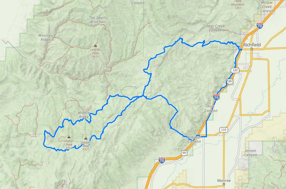
 Trail head starts on 300 North and College Avenue in Richfield. Ample trailer parking and Information Kiosk at the Trailhead. Street Legal is not required for this trail although you do travel about 500 yards on paved road. Richfield has 17 motels, a KOA campground, 27 restaurants, 4 Grocery Stores and 17 Gas Stations to choose from.
OHVsThis trail is open to all off road vehicles.. There are no width restrictions.
TerrainThe route is mostly compacted dirt with some graded gravel.
SignagePiute Trail System Route Markers on carsonite posts. The trail is well marked Traveling mostly on Piute 01.
EmergenciesClosest medical facilities Sevier Valley Hospital, Richfield: (435) 893-4100.
Utah Highway Patrol: Dial 9-1-1.
Fishlake National Forest Contact: (435) 896-9233.
Sevier County Sheriff: (435) 896-2660.
We highly recommend you purchase a Utah Search and Rescue Assistant Card (USARA), learn more: utah.gov/rescue.
Utah Highway Patrol: Dial 9-1-1.
Fishlake National Forest Contact: (435) 896-9233.
Sevier County Sheriff: (435) 896-2660.
We highly recommend you purchase a Utah Search and Rescue Assistant Card (USARA), learn more: utah.gov/rescue.
Trail head starts on 300 North and College Avenue in Richfield. Ample trailer parking and Information Kiosk at the Trailhead. Street Legal is not required for this trail although you do travel about 500 yards on paved road. Richfield has 17 motels, a KOA campground, 27 restaurants, 4 Grocery Stores and 17 Gas Stations to choose from.
This trail is open to all off road vehicles.. There are no width restrictions.
The route is mostly compacted dirt with some graded gravel.
Piute Trail System Route Markers on carsonite posts. The trail is well marked Traveling mostly on Piute 01.
Closest medical facilities Sevier Valley Hospital, Richfield: (435) 893-4100.
Utah Highway Patrol: Dial 9-1-1.
Fishlake National Forest Contact: (435) 896-9233.
Sevier County Sheriff: (435) 896-2660.
We highly recommend you purchase a Utah Search and Rescue Assistant Card (USARA), learn more: utah.gov/rescue.
Utah Highway Patrol: Dial 9-1-1.
Fishlake National Forest Contact: (435) 896-9233.
Sevier County Sheriff: (435) 896-2660.
We highly recommend you purchase a Utah Search and Rescue Assistant Card (USARA), learn more: utah.gov/rescue.