Richfield To Koosharem
- Sevier County - Richfield
- Central Utah
Menu
Trail information
Easy
Loop Trail
No width limit
Dirt Trail
Sand Trail
Single Track
50" Vehicle
S x S
Full Size
Moving Time
0
hrs
Avg Speed
0
mph
Distance
0
mi
Ascent
0
ft
Descent
0
ft
Trail head starts at the Beagle Park next to the Richfield Visitors center on north Main in Richfield. Street Legal is required for this trail. Richfield has 17 motels, a KOA campground, 27 restaurants, 4 Grocery Stores and 17 Gas Stations to choose from.
This trail is open to all off road vehicles.. There are no width restrictions and you ride this trail for the scenery, not the skill.
The route is mostly compacted dirt with some graded gravel and small sections of paved. Some travel is required on state highways.
Piute Trail System Route Markers on carsonite posts. The trail is well marked Traveling mostly on Piute 42 then switching to Piute 04 and then to 01.
Closest medical facilities Sevier Valley Hospital, Richfield: (435) 893-4100
Utah Highway Patrol: Dial 9-1-1.
Fishlake National Forest Contact: (435) 896-9233.
Sevier County Sheriff: (435) 896-2660.
We highly recommend you purchase a Utah Search and Rescue Assistant Card (USARA), learn more: utah.gov/rescue.
Utah Highway Patrol: Dial 9-1-1.
Fishlake National Forest Contact: (435) 896-9233.
Sevier County Sheriff: (435) 896-2660.
We highly recommend you purchase a Utah Search and Rescue Assistant Card (USARA), learn more: utah.gov/rescue.
- trail weather
Weather Forecast Info can´t be read at the moment!
- Description
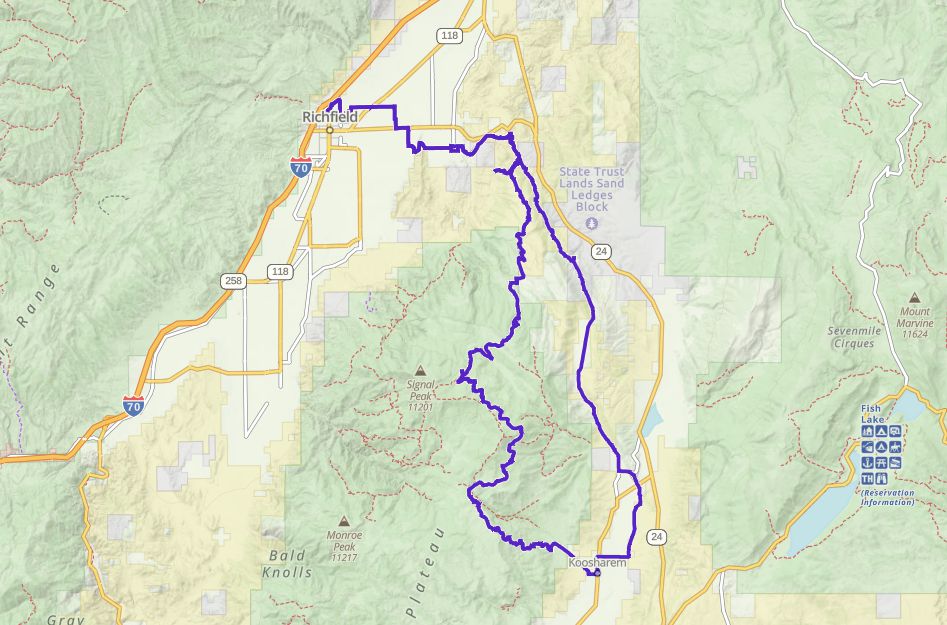
The Richfield to Koosharem Loop is a loop trail that originates at the Freedom Park at the north end of Main Street in Richfield. The route travels along surface streets and a short length of state highway so this trail will require a Street Legal Registration on your machine. The route traverses west through the Sevier valley through the town of Glenwood and then climbs up to the tops of the Sevier Plateau past Big Lake over the Magleby Pass. It then skirts along the slopes of Cove and Monroe Mountain then drops down Koosharem Canyon to the town of Koosharem. The route then heads north through the Koosharem Valley up alone the west side of Bear Valley following generally along the power lines until it rejoins the original route just above Glenwood.
The first 8 miles of this route switches back and forth between paved and dirt roads along the cool agricultural fields of Sevier Valley. After you traverse the hamlet of Glenwood you will start your assent up into the hills. Roads are generally passable on this route with very little high clearance riding.
Be sure to stop for lunch at the Koosharem Café. There fare is good home style cooking.
Maps
Trail Route

We recommend to download the GAIA App on your mobile device.
You can view and download the route from GAIA as well as see photos with their location geotagged on the trail.
360 Street View
Click “View 360 Map” to explore the trail in Google Street View and “See the Trail Before You Ride the Trail.”
Download Route
The GPX or KML files are available for you to download and use on your preferred app or device.
Key Points
Within our Key Points you will discover trail head parking, trail markers, points of interests, intersections as well as terrain and obstacles.


