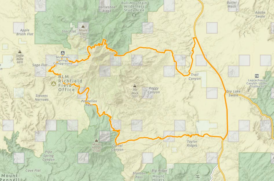
Bull Creek Pass Scenic Byway
- Garfield County - Ticaboo
Trail information
Easy
Loop Trail
No width limit
Dirt Trail
Sand Trail
Single Track
50" Vehicle
S x S
Full Size
Utah Highway Patrol: Dial 9-1-1.
NATIONAL PARK SERVICES: General Information: 928.608.6200 Bullfrog Ranger Station: (435) 684.7400 Emergency: (928) 608-6300 Emergency: (800) 582-4351.
Garfield Sheriff’s Office Search and Rescue • (435) 676-2678.
Emergencies: Wayne County Sheriff • (435) 836-1308.
We highly recommend you purchase a Utah Search and Rescue Assistant Card (USARA), learn more: utah.gov/rescue.
- trail weather
Bull Creek Pass Scenic Byway
few clouds
06:20
|
20:37
Temp: 72 / 93 / 93 ℉
|
Wind: 4 mph
|
Clouds: 19 %
* AFFECTED AREA...Fire Weather Zone 482 Western Uintah Basin, Fire Weather Zone 483 Southern Ashley National Forest, Fire Weather Zone 484 Tavaputs Plateau, Fire Weather Zone 488 Manti National Forest, Fire Weather Zone 489 San Rafael Swell, Fire Weather Zone 492 Central Utah West Desert, Fire Weather Zone 493 Central Utah Mountains, Fire Weather Zone 494 Henry Mountains, Fire Weather Zone 495 Color Country West Desert, Fire Weather Zone 496 Color Country Mountains, Fire Weather Zone 497 Mojave Desert and Fire Weather Zone 498 Grand Staircase. * WINDS...On Saturday, southwest 15 to 25 mph with gusts around 35 mph. On Sunday, southwest winds 10 to 20 mph with gusts 25 to 30 mph. * RELATIVE HUMIDITY...As low as 7 to 15 percent. * IMPACTS...Critical fire weather conditions are possible. Any new fire starts or existing fires may spread rapidly.
(NWS Salt Lake City UT)
The National Weather Service in Salt Lake City has issued a Red Flag Warning for wind and low relative humidity, which is in effect from 10 AM Saturday to 10 PM MDT Sunday. The Fire Weather Watch is no longer in effect. * AFFECTED AREA...Fire Weather Zone 482 Western Uintah Basin, Fire Weather Zone 483 Southern Ashley National Forest, Fire Weather Zone 484 Tavaputs Plateau, Fire Weather Zone 488 Manti National Forest, Fire Weather Zone 489 San Rafael Swell, Fire Weather Zone 492 Central Utah West Desert, Fire Weather Zone 493 Central Utah Mountains, Fire Weather Zone 494 Henry Mountains, Fire Weather Zone 495 Color Country West Desert, Fire Weather Zone 496 Color Country Mountains, Fire Weather Zone 497 Mojave Desert and Fire Weather Zone 498 Grand Staircase. * WINDS...On Saturday, southwest 15 to 25 mph with gusts up to 35 mph. On Sunday, southwest winds 10 to 20 mph with gusts 25 to 30 mph. Winds are expected to diminish Saturday night before redeveloping early Sunday afternoon. * RELATIVE HUMIDITY...As low as 6 to 15 percent. * IMPACTS...Critical fire weather conditions are possible. Any new fire starts or existing fires may spread rapidly.
(NWS Salt Lake City UT)
Bull Creek Pass Scenic Byway
clear sky
06:21
|
20:36
Temp: 76 / 90 / 93 ℉
|
Wind: 30 mph
|
Clouds: 1 %
* AFFECTED AREA...Fire Weather Zone 482 Western Uintah Basin, Fire Weather Zone 483 Southern Ashley National Forest, Fire Weather Zone 484 Tavaputs Plateau, Fire Weather Zone 488 Manti National Forest, Fire Weather Zone 489 San Rafael Swell, Fire Weather Zone 492 Central Utah West Desert, Fire Weather Zone 493 Central Utah Mountains, Fire Weather Zone 494 Henry Mountains, Fire Weather Zone 495 Color Country West Desert, Fire Weather Zone 496 Color Country Mountains, Fire Weather Zone 497 Mojave Desert and Fire Weather Zone 498 Grand Staircase. * WINDS...On Saturday, southwest 15 to 25 mph with gusts around 35 mph. On Sunday, southwest winds 10 to 20 mph with gusts 25 to 30 mph. * RELATIVE HUMIDITY...As low as 7 to 15 percent. * IMPACTS...Critical fire weather conditions are possible. Any new fire starts or existing fires may spread rapidly.
(NWS Salt Lake City UT)
The National Weather Service in Salt Lake City has issued a Red Flag Warning for wind and low relative humidity, which is in effect from 10 AM Saturday to 10 PM MDT Sunday. The Fire Weather Watch is no longer in effect. * AFFECTED AREA...Fire Weather Zone 482 Western Uintah Basin, Fire Weather Zone 483 Southern Ashley National Forest, Fire Weather Zone 484 Tavaputs Plateau, Fire Weather Zone 488 Manti National Forest, Fire Weather Zone 489 San Rafael Swell, Fire Weather Zone 492 Central Utah West Desert, Fire Weather Zone 493 Central Utah Mountains, Fire Weather Zone 494 Henry Mountains, Fire Weather Zone 495 Color Country West Desert, Fire Weather Zone 496 Color Country Mountains, Fire Weather Zone 497 Mojave Desert and Fire Weather Zone 498 Grand Staircase. * WINDS...On Saturday, southwest 15 to 25 mph with gusts up to 35 mph. On Sunday, southwest winds 10 to 20 mph with gusts 25 to 30 mph. Winds are expected to diminish Saturday night before redeveloping early Sunday afternoon. * RELATIVE HUMIDITY...As low as 6 to 15 percent. * IMPACTS...Critical fire weather conditions are possible. Any new fire starts or existing fires may spread rapidly.
(NWS Salt Lake City UT)
Bull Creek Pass Scenic Byway
clear sky
06:22
|
20:35
Temp: 72 / 87 / 90 ℉
|
Wind: 24 mph
|
Clouds: 0 %
* AFFECTED AREA...Fire Weather Zone 482 Western Uintah Basin, Fire Weather Zone 483 Southern Ashley National Forest, Fire Weather Zone 484 Tavaputs Plateau, Fire Weather Zone 488 Manti National Forest, Fire Weather Zone 489 San Rafael Swell, Fire Weather Zone 492 Central Utah West Desert, Fire Weather Zone 493 Central Utah Mountains, Fire Weather Zone 494 Henry Mountains, Fire Weather Zone 495 Color Country West Desert, Fire Weather Zone 496 Color Country Mountains, Fire Weather Zone 497 Mojave Desert and Fire Weather Zone 498 Grand Staircase. * WINDS...On Saturday, southwest 15 to 25 mph with gusts around 35 mph. On Sunday, southwest winds 10 to 20 mph with gusts 25 to 30 mph. * RELATIVE HUMIDITY...As low as 7 to 15 percent. * IMPACTS...Critical fire weather conditions are possible. Any new fire starts or existing fires may spread rapidly.
(NWS Salt Lake City UT)
The National Weather Service in Salt Lake City has issued a Red Flag Warning for wind and low relative humidity, which is in effect from 10 AM Saturday to 10 PM MDT Sunday. The Fire Weather Watch is no longer in effect. * AFFECTED AREA...Fire Weather Zone 482 Western Uintah Basin, Fire Weather Zone 483 Southern Ashley National Forest, Fire Weather Zone 484 Tavaputs Plateau, Fire Weather Zone 488 Manti National Forest, Fire Weather Zone 489 San Rafael Swell, Fire Weather Zone 492 Central Utah West Desert, Fire Weather Zone 493 Central Utah Mountains, Fire Weather Zone 494 Henry Mountains, Fire Weather Zone 495 Color Country West Desert, Fire Weather Zone 496 Color Country Mountains, Fire Weather Zone 497 Mojave Desert and Fire Weather Zone 498 Grand Staircase. * WINDS...On Saturday, southwest 15 to 25 mph with gusts up to 35 mph. On Sunday, southwest winds 10 to 20 mph with gusts 25 to 30 mph. Winds are expected to diminish Saturday night before redeveloping early Sunday afternoon. * RELATIVE HUMIDITY...As low as 6 to 15 percent. * IMPACTS...Critical fire weather conditions are possible. Any new fire starts or existing fires may spread rapidly.
(NWS Salt Lake City UT)
- Description
If you park at the ‘Little Egypt’ parking area, approximately 25 miles south of Hanksville on the west side of highway 95 you can checkout the Little Egypt rock formations that are reminiscent of those you might find at Goblin valley to the north, before beginning your ride.
More info on Little Egypt
More info on South Summit Ridge
Maps
Trail Route
![bull creek gaia compressed](https://outsidersutah.com/wp-content/uploads/2022/04/bull-creek-gaia_compressed.jpg)
We recommend to download the GAIA App on your mobile device.
You can view and download the route from GAIA as well as see photos with their location geotagged on the trail.
360 Street View
Click “View 360 Map” to explore the trail in Google Street View and “See the Trail Before You Ride the Trail.”
Time Lapse
Download Route
The GPX or KML files are available for you to download and use on your preferred app or device.
Key Points
Within our Key Points you will discover trail head parking, trail markers, points of interests, intersections as well as terrain and obstacles.