Facilities
  OHVs
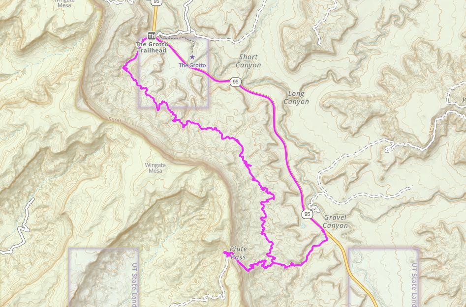
OHVs Terrain
 Signage
 Emergencies Facilities
 There are no facilities nearby. You should get food, fuel etc in Hanksville.
OHVsThis trail is passable by most OHVs of any width.
TerrainThis trail is mostly sand with occasional rocky ledges to hop over. Nothing severe and can be done mostly in two wheel drive.
SignageThere is a carsonite signage along the trial and a trail kiosk a the parking location.
EmergenciesComing Closest medical facilities Richfield (111 miles), Price (114 miles), Moab (108 miles). Utah Highway Patrol: Dial 9-1-1. We highly recommend you purchase a Utah Search and Rescue Assistant Card (USARA), learn more: utah.gov/rescue.
NATIONAL PARK SERVICES: General Information: 928.608.6200 Bullfrog Ranger Station: (435) 684.7400 Emergency: (928) 608-6300 Emergency: (800) 582-4351.
Garfield Sheriff’s Office Search and Rescue • (435) 676-2678.
Emergencies: Wayne County Sheriff • (435) 836-1308.Soon!
NATIONAL PARK SERVICES: General Information: 928.608.6200 Bullfrog Ranger Station: (435) 684.7400 Emergency: (928) 608-6300 Emergency: (800) 582-4351.
Garfield Sheriff’s Office Search and Rescue • (435) 676-2678.
Emergencies: Wayne County Sheriff • (435) 836-1308.Soon!
There are no facilities nearby. You should get food, fuel etc in Hanksville.
This trail is passable by most OHVs of any width.
This trail is mostly sand with occasional rocky ledges to hop over. Nothing severe and can be done mostly in two wheel drive.
There is a carsonite signage along the trial and a trail kiosk a the parking location.
Coming Closest medical facilities Richfield (111 miles), Price (114 miles), Moab (108 miles). Utah Highway Patrol: Dial 9-1-1. We highly recommend you purchase a Utah Search and Rescue Assistant Card (USARA), learn more: utah.gov/rescue.
NATIONAL PARK SERVICES: General Information: 928.608.6200 Bullfrog Ranger Station: (435) 684.7400 Emergency: (928) 608-6300 Emergency: (800) 582-4351.
Garfield Sheriff’s Office Search and Rescue • (435) 676-2678.
Emergencies: Wayne County Sheriff • (435) 836-1308.Soon!
NATIONAL PARK SERVICES: General Information: 928.608.6200 Bullfrog Ranger Station: (435) 684.7400 Emergency: (928) 608-6300 Emergency: (800) 582-4351.
Garfield Sheriff’s Office Search and Rescue • (435) 676-2678.
Emergencies: Wayne County Sheriff • (435) 836-1308.Soon!