Facilities
  OHVs
OHVs Terrain
 Signage
 Emergencies Facilities
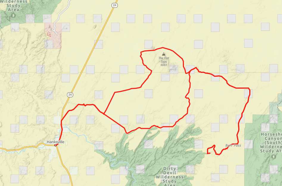
 Hanksville is where we started and ended the ride. Hanksville has gas, groceries, restaurants, hotels and a BLM office if you have questions or would like maps of the area.
OHVsAll OHVs are welcome.
TerrainDecently graded gravel roads. There are other roads in the area with less maintenance.
SignageMost of the trails have carsonite trail markers
EmergenciesClosest medical facilities Sevier Valley Hospital, Richfield: (435) 893-4100
Utah Highway Patrol or other emergencies: Dial 9-1-1.
Fishlake National Forest Contact: (435) 896-9233.
Sevier County Sheriff: (435) 896-2660.
We highly recommend you purchase a Utah Search and Rescue Assistant Card (USARA), learn more: utah.gov/rescue.
Utah Highway Patrol or other emergencies: Dial 9-1-1.
Fishlake National Forest Contact: (435) 896-9233.
Sevier County Sheriff: (435) 896-2660.
We highly recommend you purchase a Utah Search and Rescue Assistant Card (USARA), learn more: utah.gov/rescue.
Hanksville is where we started and ended the ride. Hanksville has gas, groceries, restaurants, hotels and a BLM office if you have questions or would like maps of the area.
All OHVs are welcome.
Decently graded gravel roads. There are other roads in the area with less maintenance.
Most of the trails have carsonite trail markers
Closest medical facilities Sevier Valley Hospital, Richfield: (435) 893-4100
Utah Highway Patrol or other emergencies: Dial 9-1-1.
Fishlake National Forest Contact: (435) 896-9233.
Sevier County Sheriff: (435) 896-2660.
We highly recommend you purchase a Utah Search and Rescue Assistant Card (USARA), learn more: utah.gov/rescue.
Utah Highway Patrol or other emergencies: Dial 9-1-1.
Fishlake National Forest Contact: (435) 896-9233.
Sevier County Sheriff: (435) 896-2660.
We highly recommend you purchase a Utah Search and Rescue Assistant Card (USARA), learn more: utah.gov/rescue.