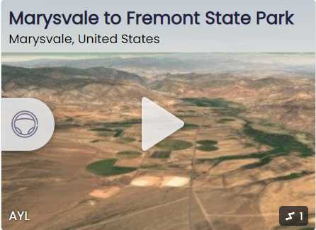
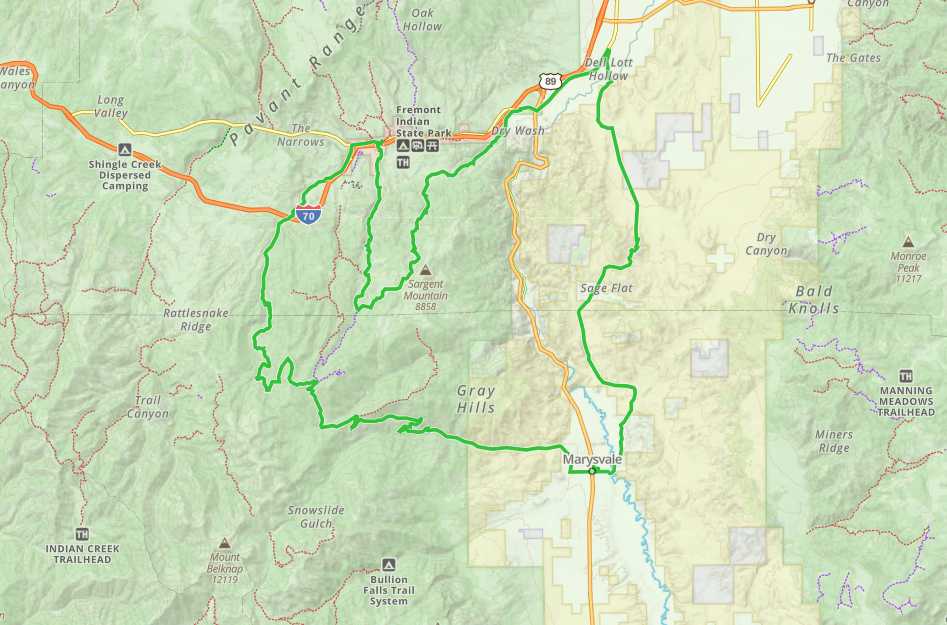
Marysvale to Fremont State Park

Trail information

Easy

Loop Trail

No width limit

dirt trail

County roads

Single Track

50" Vehicle

S x S

Full Size

0 hrs
Moving Time
0 mph
Avg Speed
0 mi
Distance
0 ft
Ascent
0 ft
Descent
Marysvale: lodging, dining, gas; Joseph: gas, convenience store, limited lodging; Fremont State Park: camping, restrooms, museum; Silver King Mine: pit toilet and parking
Street Legal OHVs (you will drive through some towns on paved roads); high clearance 4x4s on most trails.
Easy – County and Forest Roads
Well signed as part of the Paiute ATV System.
Sevier Valley Medical Center (Intermountain Healthcare), 1000 North Main, Richfield, UT 84701 (435) 893-4100
Piute County Sheriff – Dial 9-1-1 or (435) 577-2893
The trail from Marysvale to Fremont State Park is one of many side trails of the Paiute ATV Trail System. Marysvale is a great location to base from to access the Paiute trail system with a number of places to stay in town or nearby such as Piute and Otter Creek State parks. We rode right out of town and chose to run the desert portion of the trail first so we could grab a burger and a shake in Joseph and ride the mountain portion of the trail in the afternoon.

This trail has some great attractions to check out to make this a full day ride. We ran the 60-mile trail in five hours at approximately 12 mph. Use the information below to plan your trip and be sure to include stops in the town of Joseph and Fremont Indian State Park.
Maps

Trail Route

Marysvale to Fremont State Park gaia

We recommend to download the GAIA App on your mobile device.

You can view and download the route from GAIA as well as see photos with their location geotagged on the trail.

360 Street View

Click “View 360 Map” to explore the trail in Google Street View and “See the Trail Before You Ride the Trail.”

Flyover Map

 Experience a bird’s-eye view of the trail to get a better understanding of elevation changes and the surrounding terrain.

Download Route

The GPX or KML files are available for you to download and use on your preferred app or device. 

Key Points

Within our Key Points you will discover trail head parking, trail markers, points of interests, intersections as well as terrain and obstacles.

Click on the links below to reveal images and information

We started the trail right from the Marysvale City Park.
A short drive through town and you will connect with PST 2 to head back toward Joseph. This particular loop offers several different options for where you can base your adventure from. Look for our post based from Joseph for another option for this trail.
The road forks in three directions here. Stay on the center route heading north this will be PST 24.
Stay to the left on Iron Cap Road (PST 22).
Stay right to keep on PST 22.
Continue on north following the sign for PST 22. The contrast between the mountain roads and the flat of the desert offers a variety of scenary and an escape from the heat in the summer.
Stay right on PST 22 heading northeast.
Turn right at the fork to stay on PST 22 (Ross Lane).
Follow Ross Lane.
This is the end of PST 22 and ties into PST 10. From here you can continue on back to Joseph by heading north.
Visitor center and museum.
You can run this loop from several different starting points including Marysvale, Fremont State Park and Joseph. We fueled up in Joseph before heading to Fremont State Park and unloading at Rendezvouz Flat. Follow the instructions for day use and camping fees.
There is access to 50″ riding here. Otherwise follow PST 13 (Max Reid Trail Sign).
Follow the road south where it will transition into gravel continuing on the west side of I-70.
Continue riding south following the sign for Kimberly.
Spring or fall this is an amazing ride.
Winkler Point (9869 ft.), named in honor of Ernest Winkler.
50″ Access to the Max Reid Trail 1. We continued on Paiute Side Trail (PST) 13.
The Silver King Mine offers a historical stop complete with pit toilet and a parking area nearby.
An example of some of the riding at elevation with trees off to either side of the road.
Continue on south to Marysvale. *The Deer Creek Trail continues on down the mountain to Highway 89 near the Big Rock Candy Mountain.
trail video
Share The Trail
Facebook
Twitter
LinkedIn
Email
WhatsApp
comments
0.0
Rated 0.0 out of 5
0.0 out of 5 stars (based on 0 reviews)
Excellent0%
Very good0%
Average0%
Below Average0%
Poor0%

There are no comments yet be the first to write one :)

Related Trails

We add new trails every week!

Receive the latest trails, as well as updates on outdoor recreation and off-road events in Utah.
Join our community!

small_c_popup.png

Thank You For Joining Outsiders!!