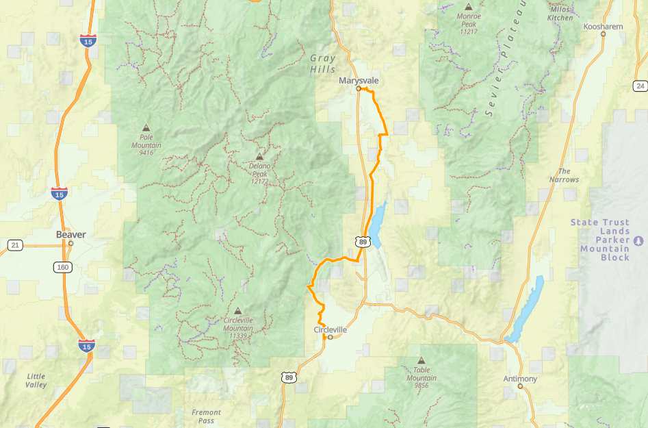
Marysvale to Circleville Trail
- Sevier County - Marysvale
Menu
Trail information
Easy
Out & Back
No width limit
Dirt Trail
Sand Trail
Single Track
50" Vehicle
S x S
Full Size
Moving Time
0
hrs
Avg Speed
0
mph
Distance
0
mi
Ascent
0
ft
Descent
0
ft
Facilities
OHVs
Terrain
Signage
Emergencies
Facilities
Food and supplies at Otter Creek Reservior Fuel, Food and Lodging in Marysvale
OHVs
No width limits. ATVs, MCs, UTVs, 4x4s on most trails.
Terrain
Mostly graded County Roads
Signage
The main routes have adequate signage.
Emergencies
Circleville Clinic, 145 W Main Street, Circleville, UT 84723
Sevier County Sheriff: Dial 9-1-1 or (435) 896-2600; Utah Highway Patrol – Richfield: Dial 9-1-1 or (435) 896-2780.
We highly recommend you purchase a Utah Search and Rescue Assistant Card (USARA), learn more: utah.gov/rescue
Sevier County Sheriff: Dial 9-1-1 or (435) 896-2600; Utah Highway Patrol – Richfield: Dial 9-1-1 or (435) 896-2780.
We highly recommend you purchase a Utah Search and Rescue Assistant Card (USARA), learn more: utah.gov/rescue
Food and supplies at Otter Creek Reservior Fuel, Food and Lodging in Marysvale
No width limits. ATVs, MCs, UTVs, 4x4s on most trails.
Mostly graded County Roads
The main routes have adequate signage.
Circleville Clinic, 145 W Main Street, Circleville, UT 84723
Sevier County Sheriff: Dial 9-1-1 or (435) 896-2600; Utah Highway Patrol – Richfield: Dial 9-1-1 or (435) 896-2780.
We highly recommend you purchase a Utah Search and Rescue Assistant Card (USARA), learn more: utah.gov/rescue
Sevier County Sheriff: Dial 9-1-1 or (435) 896-2600; Utah Highway Patrol – Richfield: Dial 9-1-1 or (435) 896-2780.
We highly recommend you purchase a Utah Search and Rescue Assistant Card (USARA), learn more: utah.gov/rescue
- trail weather
Weather Forecast Info can´t be read at the moment!
- Description
Marysvale to Circleville is a short exciting drive passing through great mountian scenery, Dock Spring and the Piute Reservoir. Be sure to stock up on supplies at the Sinclair convenience store before you depart or choose nearby Junction. A fun drive to the south will take you through BLM and state land. The open and winding valleys make for a great half-day trip!
This trail is about 27 miles “one way” and it takes about 2 hours to complete with average speed 13mph.
Maps
Trail Route
We recommend to download the GAIA App on your mobile device.
You can view and download the route from GAIA as well as see photos with their location geotagged on the trail.
360 Street View
Click “View 360 Map” to explore the trail in Google Street View and “See the Trail Before You Ride the Trail.”
Download Route
The GPX or KML files are available for you to download and use on your preferred app or device.
Key Points
Within our Key Points you will discover trail head parking, trail markers, points of interests, intersections as well as terrain and obstacles.
Click on the links below to reveal images and information
Start at Lizzie & Charlie’s RV / ATV Park right off of Main Street.
Follow East 100 North until you reach BM 5831. This is the start of the trail.
Depart to the right to begin the main trail to Circleville.
Cut into this left fork on the trail to continue forward.
Crossover the main trail here. Continue forward for a good stretch.
You will follow a mostly straight paths until you reach a turn onto Monroe Mountain where you will take a right turn.
Turn left here onto South Thompsvill Road.
Continue south through Gold Gulch and take a right turn when the road forks.
Proceed straight until you take another turn to the left onto Old US Highway 89.
Here you will be passing Pauite Reservior! Enjoy the view.
Cross over Highway 89 here.
The road will begin to curve and after the road will continue on straight for quite some time.
Cross to Highway 153 and enjoy the smooth ride.
Get ready to take a left turn on to Forest Road 133. There may be different trails to get through this section but this one worked best for us.
Continue exclusively southwest until you reach this fork in the road (FR133).
Head southeast now until there is a turn in the road to the right.
At West Side Circleville Road, cross over.
This is the home stretch. Go through this bend in the road and you’re almost to Circleville.
Welcome to Circleville, Utah! Stay a while and enjoy.