Facilities
  OHVs
OHVs Terrain
 Signage
 Emergencies Facilities
 Lodging, restaurants, fuel and groceries are all available in Kanab, Utah. There are some trailheads, pit toilets and parking areas on the return trip of the loop as you cross back into Utah near the Vermillion Cliffs National Monument.
OHVsAll sizes. No width limits. ATVs, MCs, UTVs, 4x4s on most trails.
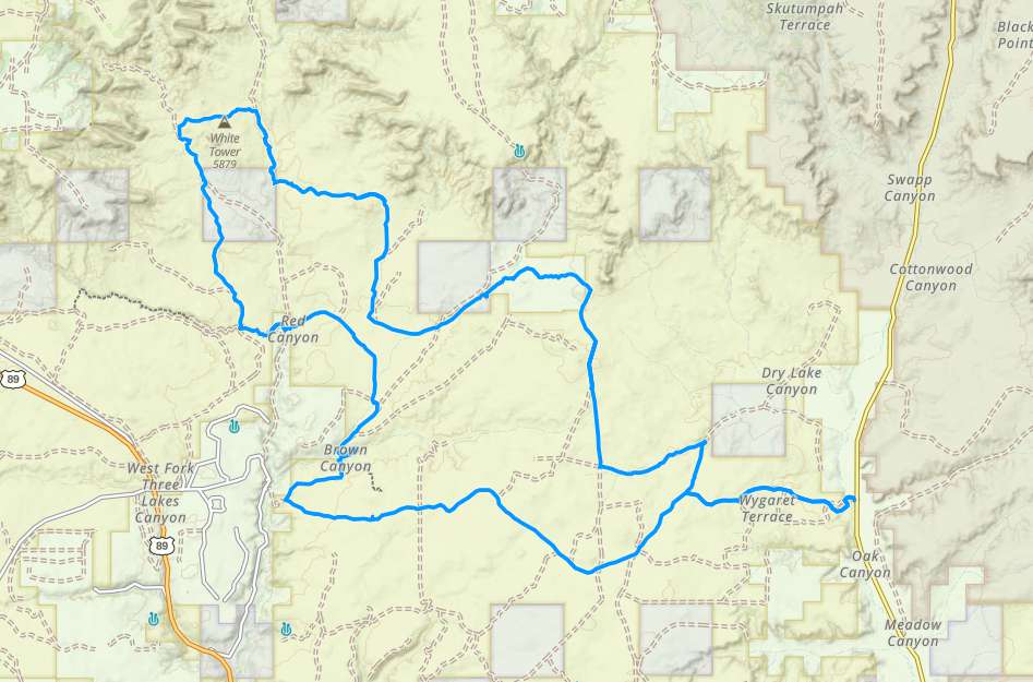
TerrainMostly graded county roads.
SignageThis trail is not well signed, this is a good one to use your GPS on (see below).
EmergenciesThe closest medical help is the hospital in Kanab • 355 N. Main Street, Kanab, UT 84741 (435) 644-5811 (Open 24 hours) or in Page, AZ, 501 N Navajo Drive. Open 24 hours (928) 645-2424.
Kane County Sheriff: Dial 9-1-1 for emergencies or Non-Emergency Dispatch: (435) 644-2349; Utah Highway Patrol: Dial 9-1-1
Kane County Sheriff: Dial 9-1-1 for emergencies or Non-Emergency Dispatch: (435) 644-2349; Utah Highway Patrol: Dial 9-1-1
Lodging, restaurants, fuel and groceries are all available in Kanab, Utah. There are some trailheads, pit toilets and parking areas on the return trip of the loop as you cross back into Utah near the Vermillion Cliffs National Monument.
All sizes. No width limits. ATVs, MCs, UTVs, 4x4s on most trails.
Mostly graded county roads.
This trail is not well signed, this is a good one to use your GPS on (see below).
The closest medical help is the hospital in Kanab • 355 N. Main Street, Kanab, UT 84741 (435) 644-5811 (Open 24 hours) or in Page, AZ, 501 N Navajo Drive. Open 24 hours (928) 645-2424.
Kane County Sheriff: Dial 9-1-1 for emergencies or Non-Emergency Dispatch: (435) 644-2349; Utah Highway Patrol: Dial 9-1-1
Kane County Sheriff: Dial 9-1-1 for emergencies or Non-Emergency Dispatch: (435) 644-2349; Utah Highway Patrol: Dial 9-1-1