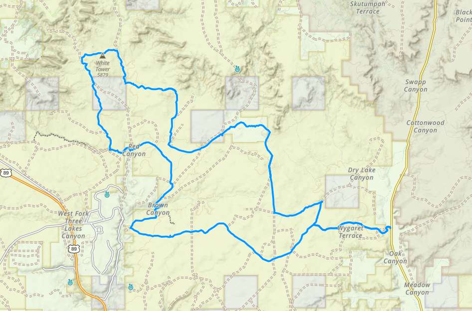
Crocodile – Johnson

Trail information

Easy

Loop Trail

No width limit

Sand Trail

Single Track

50" Vehicle

S x S

Full Size

0 hrs
Moving Time
0 mph
Avg Speed
0 mi
Distance
0 ft
Ascent
0 ft
Descent
Lodging, restaurants, fuel and groceries are all available in Kanab, Utah. There are some trailheads, pit toilets, and parking areas on the return trip of the loop as you cross back into Utah near the Vermillion Cliffs National Monument.
All sizes. No width limits. ATVs, MCs, UTVs, 4x4s on most trails.
Sandy ATV trails with some overgrown junipers to squeeze through.
There are some intersections that can be a little confusing that are marked with carsonite signage. Look at our notes below and download a GPS track (see below).
The closest medical help is the hospital in Kanab • 355 N. Main Street, Kanab UT 84741 (435) 644-5811 or in Page, AZ • 501 N Navajo Drive (928) 645-2424.
Kane County Sheriff: Dial 9-1-1 for emergencies or Non-Emergency Dispatch: (435) 644-2349 • Utah Highway Patrol: Dial 9-1-1.
The Crocodile Loop OHV Trail is a 40 mile day ride on the smooth sandy trails that twist through the junipers and washes of the flats to the east of Highway 89. The spectacular white cliffs of the Grand Staircase lie in the distance to the north with some monoliths rising from the desert flat close to the trail waiting to be explored. Peekaboo Slot Canyon isn’t far from this route either. The sandy trails make for a smooth although dusty ride that the whole family ought to enjoy. It took us 4.5 hours to run the trail at approximately 9 mph.

Leave early if you are going to make this run in the summer. There are a few places to escape the sun among the rocks and junipers. However, this is a ride better suited for the early spring, fall or winter (the area looks very different when the sun lies farther south in the sky).

Kanab serves as a great basecamp, providing opportunities for lodging that will keep you close enough to the trailhead that you can both escape civilization for a ride but return for a hot shower and a meal.

This is an awesome ride to add to your itinerary if you are visiting nearby Coral Pink Sand Dunes State Park, Zion National Park and even St. George.
Maps

Trail Route

Crocodile gaia

We recommend to download the GAIA App on your mobile device.

You can view and download the route from GAIA as well as see photos with their location geotagged on the trail.

360 Street View

Click “View 360 Map” to explore the trail in Google Street View and “See the Trail Before You Ride the Trail.”

Flyover Map

 Experience a bird’s-eye view of the trail to get a better understanding of elevation changes and the surrounding terrain.

Download Route

The GPX or KML files are available for you to download and use on your preferred app or device. 

Key Points

Within our Key Points you will discover trail head parking, trail markers, points of interests, intersections as well as terrain and obstacles.

Click on the links below to reveal images and information

The Crocodile staging area has a good parking area for your truck and trailer, pit toilets and kiosk. Turn left a short distance down the road to follow the sign for the Hog Canyon OHV riding area.
Turn right to head northeast onto the loop. This is all part of Route 100 of the trail.
Heading north this is a great example of the scenery and riding on this trail. Cutler Point juts out from the desert in front of you. Follow the trail from this view to see how close you will be riding to it. This is a beautiful landmark for some photography.
Riding through a wash we find some deeper sand you’ll want to float over.
There are a few places where the junipers really hug the trail if you aren’t adverse to a little Rocky Mountain pinstriping on your machine.
An area where the junipers subside and the view opens up of one of the geologic steps of the Grand Staircase.
From the trail looking at White Tower.
Continue straight on Route 102.
A short jaunt from the loop is the trailhead for Peekaboo Slot Canyon. This is a relatively easy hike and a cool slot canyon to explore especially in the heat of the summer. Pay attention the the weather though because this area is susceptible to flash flooding.
Another cool place to stop and find some shade and maybe let the kids play for a bit.
Turn left to head east.
Stay to the right continuing east.
Continue straight on Route 100 heading south. Pay attention to the GPS track if you downloaded it because you can loop back to an earlier segment of the trail here, which we did while we were out on this ride.
Turn right to head east and back to the parking area.
trail video
Share The Trail
Facebook
Twitter
LinkedIn
Email
WhatsApp
comments
0.0
Rated 0.0 out of 5
0.0 out of 5 stars (based on 0 reviews)
Excellent0%
Very good0%
Average0%
Below Average0%
Poor0%

There are no comments yet be the first to write one :)

Related Trails

We add new trails every week!

Receive the latest trails, as well as updates on outdoor recreation and off-road events in Utah.
Join our community!

small_c_popup.png

Thank You For Joining Outsiders!!