Castle Cliffs
- Washington County
Menu
Trail information
Easy
Loop Trail
No width limit
Dirt Trail
graded roads
Single Track
50" Vehicle
S x S
Full Size
Moving Time
0
hrs
Avg Speed
0
mph
Distance
0
mi
Ascent
0
ft
Descent
0
ft
No Facilities on the trail (some designated primative camping), Fuel, Food and Lodging in nearby St George, Utah
All sizes. No width limits. ATVs, MCs, UTVs, 4x4s on most trails. Riding is restricted to designated trails.
Mostly Graded County Roads
The main routes have adequate signage
The closest medical help is St. George Regional Hospital. 1380 E Medical Center Drive, St George, UT 84790. (435) 251-1000, Dial 9-1-1 for emergencies. Washington County Sheriff: 620 S 5300 W, Hurricane, UT 84737 (435) 656-6500. Dial 9-1-1 for emergencies. Utah Highway Patrol: Dial 9-1-1
We highly recommend you purchase a Utah Search and Rescue Assistant Card (USARA), learn more: utah.gov/rescue
We highly recommend you purchase a Utah Search and Rescue Assistant Card (USARA), learn more: utah.gov/rescue
- trail weather
Weather Forecast Info can´t be read at the moment!
- Description
Castle Cliffs OHV trail is a scenic desert ride in a unique corner of Southwest Utah where the Great Basin transitions into the Mojave Desert. This area is part of the Beaver Dam Wash National Conservation Area (NCA), please stay on established roads and marked trails. This is a great trail adventure in the winter, early spring and fall. Below you will find map resources and some suggestions for riding in this area.
Our ride took about five hours at 12 mph covering a distance of 50 miles. Riding consists of mostly graded county roads in the conservation area but some of the roads may be subject to washouts.
The trail begins directly off Old Highway 91 west of St. George, offering an escape from the bustling city while keeping the amenities of a first class resort town nearby. There are currently no facilities on this trail other than some primitive designated camping areas. Be sure to stock up on supplies before heading out.
Maps
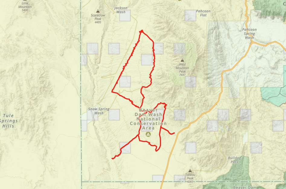
Trail Route

We recommend to download the GAIA App on your mobile device.
You can view and download the route from GAIA as well as see photos with their location geotagged on the trail.
360 Street View
Click “View 360 Map” to explore the trail in Google Street View and “See the Trail Before You Ride the Trail.”
Download Route
The GPX or KML files are available for you to download and use on your preferred app or device.
Key Points
Within our Key Points you will discover trail head parking, trail markers, points of interests, intersections as well as terrain and obstacles.
Click on the links below to reveal images and information
There is an area to park off highway 91 at the Hole in the Rock Pulloff or take the Lytle Ranch Road and stage from the trailhead a few miles from the highway.
Turn right heading north at the sign for Welcome Spring Pipeline.
Welcome Spring Climbing Site from this point continue on around the curve and you will head westward on the trail.
Turn left to turn into the wash.
At the right time of year (December), snow makes a real contrast to the desert.
Stay left to keep on the loop trail. There is a designated campsite off to the right. The road to the left is a dead end.
This is a challenging section where areas of the road might be washed out.
The trail ties back into the Lytle Ranch Road (the road you came in on). Head right to continue on west.
Turn left. There is a designated camping area (#26) off the road. If you continue on you can ride another loop off the main road continuing on to the next intersection. Turn right onto Indian Springs Trail heading north.
Joshua Trees lining the trail look like something out of Dr. Suess.


