Facilities
  OHVs
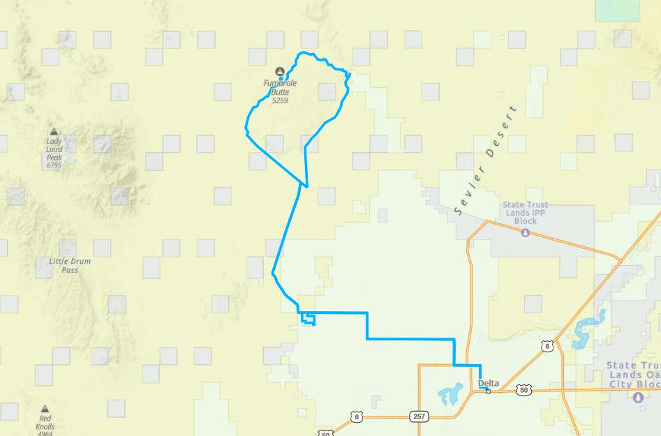
OHVs Terrain
 Signage
 Emergencies Facilities
 Delta as a base camp has a variety of lodging options: 4 motels, and an RV park. There are 8 different restaurants or food joints (not counting Maverick). Provisions are easy to find as Delta has two grocery stores and both a Dollar General and Family Dollar store. There is a stand alone pharmacy on Main Street. Hardware can be found at the IFA store, and Ace Hardware and a full service lumber yard.
OHVsNo width Limit on this trail.
TerrainThis is the west desert and this ride is mostly flat. You will be looking at two of the tallest landmarks for miles around, but they are worth exploring. A small amount of paved, but mostly dirt roads and trails. This is the driest part of the state, bring water, even on a cool day!.
SignageIf you keep an eye out, you will be able to follow signs from Delta to Topaz and from Topaz there is only one route to the northwest.
EmergenciesMillard County Sheriff: Emergency call 911.
Non Emergency:
Fillmore (435) 743-5302
Delta (435) 864-2755
Garrison (435) 855-2162
Millard County Fire: 911
Hospital: Delta Community Hospital (435) 864-5591
Non Emergency:
Fillmore (435) 743-5302
Delta (435) 864-2755
Garrison (435) 855-2162
Millard County Fire: 911
Hospital: Delta Community Hospital (435) 864-5591
Delta as a base camp has a variety of lodging options: 4 motels, and an RV park. There are 8 different restaurants or food joints (not counting Maverick). Provisions are easy to find as Delta has two grocery stores and both a Dollar General and Family Dollar store. There is a stand alone pharmacy on Main Street. Hardware can be found at the IFA store, and Ace Hardware and a full service lumber yard.
No width Limit on this trail.
This is the west desert and this ride is mostly flat. You will be looking at two of the tallest landmarks for miles around, but they are worth exploring. A small amount of paved, but mostly dirt roads and trails. This is the driest part of the state, bring water, even on a cool day!.
If you keep an eye out, you will be able to follow signs from Delta to Topaz and from Topaz there is only one route to the northwest.
Millard County Sheriff: Emergency call 911.
Non Emergency:
Fillmore (435) 743-5302
Delta (435) 864-2755
Garrison (435) 855-2162
Millard County Fire: 911
Hospital: Delta Community Hospital (435) 864-5591
Non Emergency:
Fillmore (435) 743-5302
Delta (435) 864-2755
Garrison (435) 855-2162
Millard County Fire: 911
Hospital: Delta Community Hospital (435) 864-5591