Facilities
  OHVs
OHVs Terrain
 Signage
 Emergencies Facilities
 The city of Delta has all of the facilities you could need. Gas, Groceries, hotels and Air B&B are all available.
OHVsThis trail is good for all vehicles capable of travel on loose sand.
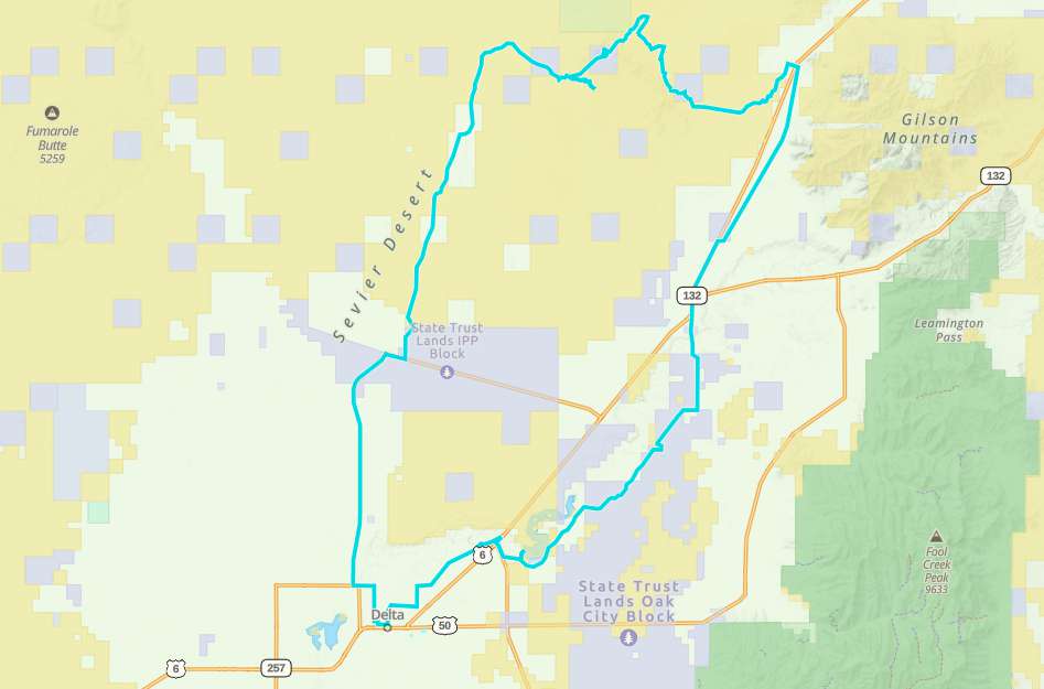
TerrainThe trail starts in the city of Delta on pavement and changes to gravel near the IPP power plant. As it approaches the Dunes the trail turns to loose sand. There are several places where navigating the dunes can be tricky as the dunes shift and change often.
SignageThere are no signs, get the GPS track.
EmergenciesDelta Community Hospital
126 S White Sage Ave Delta, UT 84624
435-864-5591
Dial 911 for Emergencies
Millard County Sheriff (435) 743-5302
569-647 UT-99, Fillmore, UT 84631
Utah Highway Patrol (435) 743-6653
BLM Office in Fillmore (435)743-3123
126 S White Sage Ave Delta, UT 84624
435-864-5591
Dial 911 for Emergencies
Millard County Sheriff (435) 743-5302
569-647 UT-99, Fillmore, UT 84631
Utah Highway Patrol (435) 743-6653
BLM Office in Fillmore (435)743-3123
The city of Delta has all of the facilities you could need. Gas, Groceries, hotels and Air B&B are all available.
This trail is good for all vehicles capable of travel on loose sand.
The trail starts in the city of Delta on pavement and changes to gravel near the IPP power plant. As it approaches the Dunes the trail turns to loose sand. There are several places where navigating the dunes can be tricky as the dunes shift and change often.
There are no signs, get the GPS track.
Delta Community Hospital
126 S White Sage Ave Delta, UT 84624
435-864-5591
Dial 911 for Emergencies
Millard County Sheriff (435) 743-5302
569-647 UT-99, Fillmore, UT 84631
Utah Highway Patrol (435) 743-6653
BLM Office in Fillmore (435)743-3123
126 S White Sage Ave Delta, UT 84624
435-864-5591
Dial 911 for Emergencies
Millard County Sheriff (435) 743-5302
569-647 UT-99, Fillmore, UT 84631
Utah Highway Patrol (435) 743-6653
BLM Office in Fillmore (435)743-3123