Facilities
  OHVs
OHVs Terrain
 Signage
 Emergencies Facilities
 Lodging, restaurants, fuel and groceries are all available in Circleville. There are no services available along the trail.
OHVsAll sizes. No width limits. ATVs, MCs, UTVs, 4x4s on most trails.
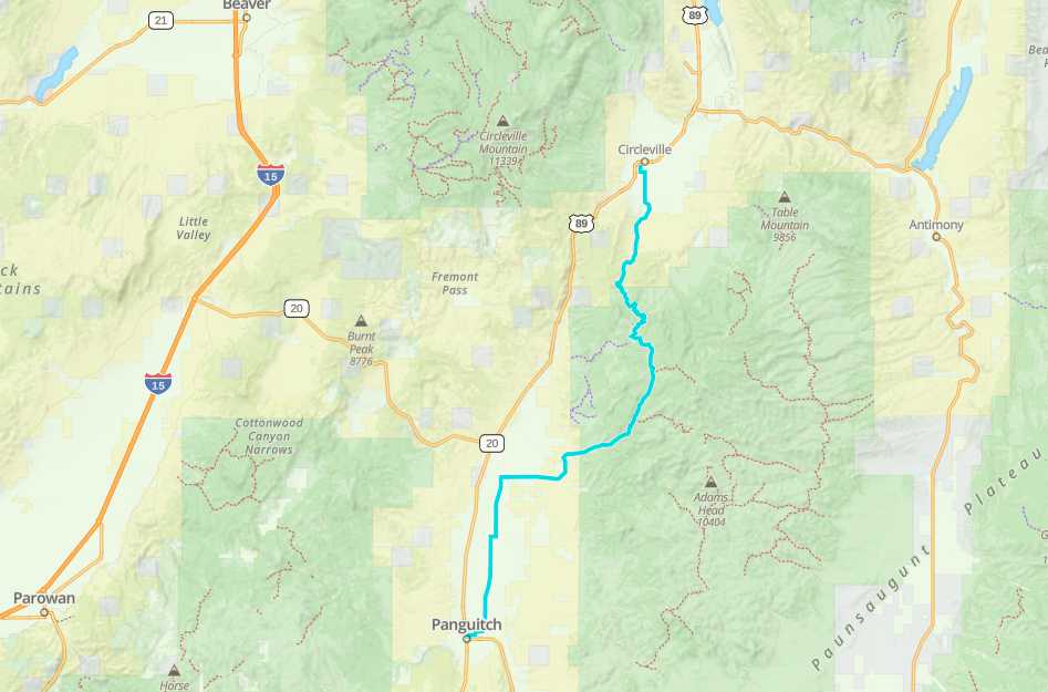
TerrainMostly dirt and gravel roads.
SignageThe area is signed fairly well but some of the signs are weathered. Look at our notes below and download a GPS track.
EmergenciesGarfield Memorial Hospital 200 N 400 E Panguitch, UT 84759 (435) 676-8811 or
Sevier Valley Medical Center (Intermountain), 1000 North Main Street, Richfield, UT 84701 (435) 893-4100
Utah Highway Patrol Dial 9-1-1.
We highly recommend you purchase a Utah Search and Rescue Assistant Card (USARA) learn more: utah.gov/rescue
Sevier Valley Medical Center (Intermountain), 1000 North Main Street, Richfield, UT 84701 (435) 893-4100
Utah Highway Patrol Dial 9-1-1.
We highly recommend you purchase a Utah Search and Rescue Assistant Card (USARA) learn more: utah.gov/rescue
Lodging, restaurants, fuel and groceries are all available in Circleville. There are no services available along the trail.
All sizes. No width limits. ATVs, MCs, UTVs, 4x4s on most trails.
Mostly dirt and gravel roads.
The area is signed fairly well but some of the signs are weathered. Look at our notes below and download a GPS track.
Garfield Memorial Hospital 200 N 400 E Panguitch, UT 84759 (435) 676-8811 or
Sevier Valley Medical Center (Intermountain), 1000 North Main Street, Richfield, UT 84701 (435) 893-4100
Utah Highway Patrol Dial 9-1-1.
We highly recommend you purchase a Utah Search and Rescue Assistant Card (USARA) learn more: utah.gov/rescue
Sevier Valley Medical Center (Intermountain), 1000 North Main Street, Richfield, UT 84701 (435) 893-4100
Utah Highway Patrol Dial 9-1-1.
We highly recommend you purchase a Utah Search and Rescue Assistant Card (USARA) learn more: utah.gov/rescue