Facilities
  OHVs
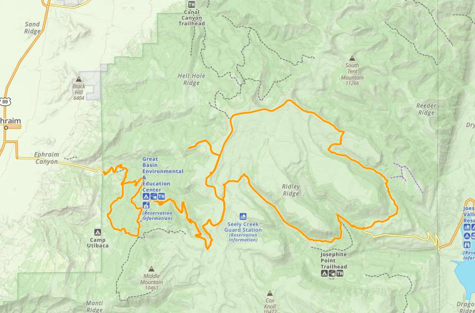
OHVs Terrain
 Signage
 Emergencies Facilities
 Nearby Ephraim offers a great basecamp with motels, restaurants and fuel.
OHVs*Some trails with width limits. ATVs, MCs, UTVs, 4x4s on most trails.
TerrainMostly dirt roads and very few rocky areas.
SignageMost trails have adequate signage.
EmergenciesThe closest medical help is the Ephraim Medical Clinic at 525 N Main Street, Ephraim, UT 84627 Phone: (435) 283-4076
Dial 9-1-1 for emergencies.
Sanpete County Sheriff: Dial 9-1-1 or 435-835-2191 for non emergencies. 1500 S Hwy 89, Manti, UT 84642
Utah Highway Patrol: Dial 9-1-1
We highly recommend you purchase a Utah Search and Rescue Assistant Card (USARA), learn more: utah.gov/rescue
Dial 9-1-1 for emergencies.
Sanpete County Sheriff: Dial 9-1-1 or 435-835-2191 for non emergencies. 1500 S Hwy 89, Manti, UT 84642
Utah Highway Patrol: Dial 9-1-1
We highly recommend you purchase a Utah Search and Rescue Assistant Card (USARA), learn more: utah.gov/rescue
Nearby Ephraim offers a great basecamp with motels, restaurants and fuel.
*Some trails with width limits. ATVs, MCs, UTVs, 4x4s on most trails.
Mostly dirt roads and very few rocky areas.
Most trails have adequate signage.
The closest medical help is the Ephraim Medical Clinic at 525 N Main Street, Ephraim, UT 84627 Phone: (435) 283-4076
Dial 9-1-1 for emergencies.
Sanpete County Sheriff: Dial 9-1-1 or 435-835-2191 for non emergencies. 1500 S Hwy 89, Manti, UT 84642
Utah Highway Patrol: Dial 9-1-1
We highly recommend you purchase a Utah Search and Rescue Assistant Card (USARA), learn more: utah.gov/rescue
Dial 9-1-1 for emergencies.
Sanpete County Sheriff: Dial 9-1-1 or 435-835-2191 for non emergencies. 1500 S Hwy 89, Manti, UT 84642
Utah Highway Patrol: Dial 9-1-1
We highly recommend you purchase a Utah Search and Rescue Assistant Card (USARA), learn more: utah.gov/rescue