Facilities
  OHVs
OHVs Terrain
 Signage
 Emergencies Facilities
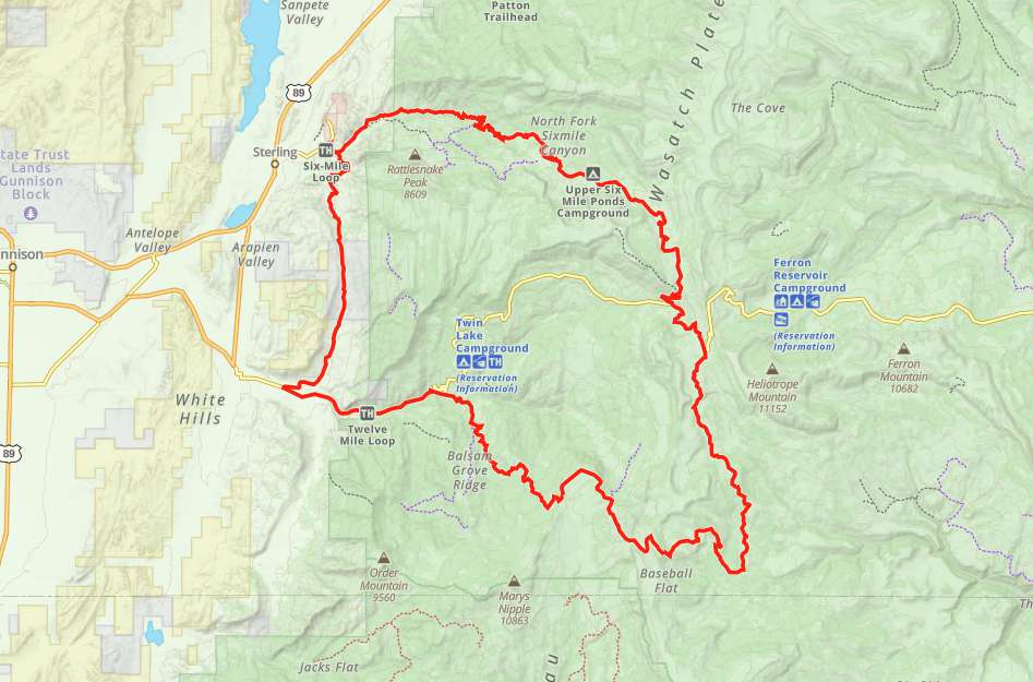
 Nearby Manti and Sterling are good places to stock up on fuel and supplies. Palisades State Park or a number of nearby campgrounds can serve as a base camp.
OHVs*Some 66″ width limits on sections of this trail. ATVs, MCs, UTVs, 4x4s on most trails.
TerrainMostly dirt and little bit rocky.
SignageMost trails have adequate signage.
EmergenciesThe closest medical help is Gunnison Valley Hospital, 64 E 100 N Street, Gunnison, UT 84634. (435) 528-7246.
Dial 9-1-1 for emergencies.
Sanpete County Sheriff: Dial 9-1-1 or (435) 835-2191. 1500 S Hwy 89, Manti, UT 84642
Utah Highway Patrol: Dial 9-1-1
We highly recommend you purchase a Utah Search and Rescue Assistant Card (USARA), learn more: utah.gov/rescue
Dial 9-1-1 for emergencies.
Sanpete County Sheriff: Dial 9-1-1 or (435) 835-2191. 1500 S Hwy 89, Manti, UT 84642
Utah Highway Patrol: Dial 9-1-1
We highly recommend you purchase a Utah Search and Rescue Assistant Card (USARA), learn more: utah.gov/rescue
Nearby Manti and Sterling are good places to stock up on fuel and supplies. Palisades State Park or a number of nearby campgrounds can serve as a base camp.
*Some 66″ width limits on sections of this trail. ATVs, MCs, UTVs, 4x4s on most trails.
Mostly dirt and little bit rocky.
Most trails have adequate signage.
The closest medical help is Gunnison Valley Hospital, 64 E 100 N Street, Gunnison, UT 84634. (435) 528-7246.
Dial 9-1-1 for emergencies.
Sanpete County Sheriff: Dial 9-1-1 or (435) 835-2191. 1500 S Hwy 89, Manti, UT 84642
Utah Highway Patrol: Dial 9-1-1
We highly recommend you purchase a Utah Search and Rescue Assistant Card (USARA), learn more: utah.gov/rescue
Dial 9-1-1 for emergencies.
Sanpete County Sheriff: Dial 9-1-1 or (435) 835-2191. 1500 S Hwy 89, Manti, UT 84642
Utah Highway Patrol: Dial 9-1-1
We highly recommend you purchase a Utah Search and Rescue Assistant Card (USARA), learn more: utah.gov/rescue