Charlie Park Trails

Trail information

Easy

Out & Back

No width limit

Dirt Trail

rocky Trail

Single Track

50" Vehicle

S x S

Full Size

0 hrs
Moving Time
0 mph
Avg Speed
0 mi
Distance
0 ft
Ascent
0 ft
Descent
None. You may encounter Gates, Leave them as you find them.
All OHVs: 50″ ATV’s, UTV’s & MC’s and full-sized 4x4s.
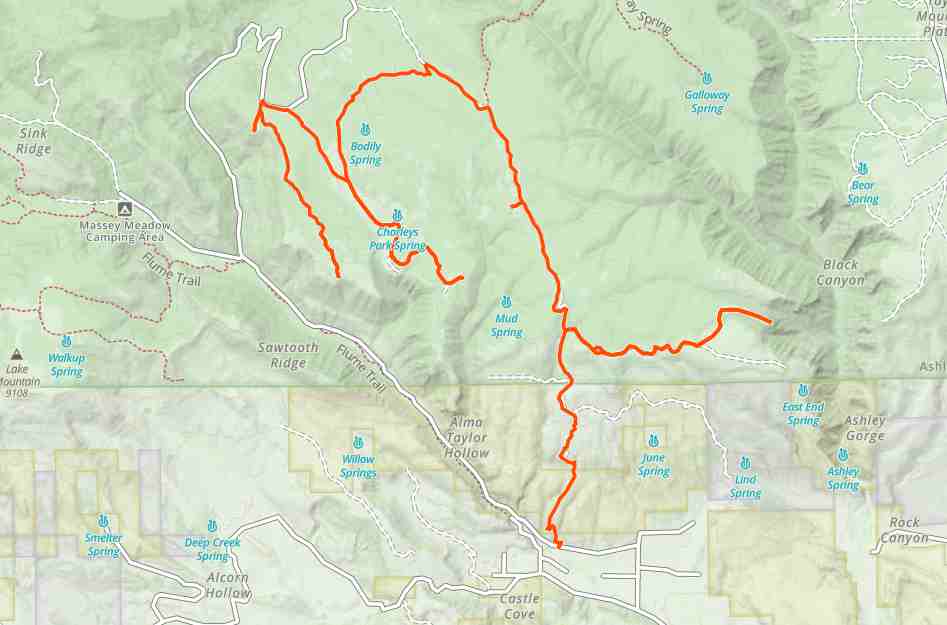
Mostly rocky and dirt roads.
Most Trails have adequate signage.
The closest medical help is Ashley Regional Medical Cente 150 W 100 N, Vernal, UT 84078 Dial 911 for Emergencies or (435) 789-3342

Uintah County Sheriff’s Office 641 E 300 S, Vernal, UT 84078 Dial 911 for Emergencies or (435) 789-2511

Utah Highway Patrol Dial 911 641 East, 300 South, Suite 300
Vernal, Utah 84078 (435) 781-6740

Ashley National Forest 355 North Vernal Avenue Vernal, UT 8407 435-789-1181
The Charlie trails are located in Uintah County approximately 14 miles North West of Vernal UT in Dry Fork Canyon, and 220 miles East of Salt Lake City Utah. The trailhead (such as it is) is located at 40.5647694,-109.6879361 Just 2,000 Feet north of the Red Cloud Loop and Dry Fork Settlement Rd Intersection. There is limited parking at the intersection (Don’t block the gates). While the Road you will take is called West Red Cloud Loop Rd there are no signs to that effect and the road might even appear to be private as the beginning is poorly maintained. While we rode approximately 27 miles there are many many more miles or trail in the area. It will take you a 3-4 hours to explore this system depending on your driving and whether you take some of the side trails available. There are no services so stock up on anything you need before leaving Vernal.
Maps

Trail Route

Charlie Park Trails gaia

We recommend to download the GAIA App on your mobile device.

You can view and download the route from GAIA as well as see photos with their location geotagged on the trail.

360 Street View

Click “View 360 Map” to explore the trail in Google Street View and “See the Trail Before You Ride the Trail.”

Flyover Map

 Experience a bird’s-eye view of the trail to get a better understanding of elevation changes and the surrounding terrain.

Download Route

The GPX or KML files are available for you to download and use on your preferred app or device. 

Key Points

Within our Key Points you will discover trail head parking, trail markers, points of interests, intersections as well as terrain and obstacles.

Click on the links below to reveal images and information

Due to a recent fire, the view up on top is unrestricted.
After an initial rough section of trail, we have smooth sailing most of the rest of the trails in Charlie Park.
While you may not encounter many other riders here, you will find plenty of cows all over the mountain. Please don’t harass them and slow down to a crawl when passing.
There are plenty of dead-end trails in Charley Park but with a view like this in the end, they are worth the trip.
This is typical of much of the trail up on top. Mixed conifers and Aspens.
You may encounter logging equipment and a bunch of dead-end side roads. If they look like this one they are most certainly logging access roads that simply end a few hundred yards away from the main roads.
The Forest Service recently filled this muddy intersection with gravel. We are going to hang a Left here and head west into the other sections of Charlie Park.
Charley Park is famous for it’s enormous mountain meadows. Keep an eye out for cows and deer. We will keep left to head to the south end.

Remember those cows we mentioned? If you encounter a large herd in the road just slow to a crawl and they will step out of your way. Please don’t scare or harass them. They belong to this guy and he knows everything about this mountain. Stop and say hi. The dogs were friendly but we could tell they wanted to get to work.

This is Charley Park Spring inside that rail fenced circle.
We found the end, such as it is. I guess not every dead-end has a spectacular view.
While this was the end of our ride there is plenty more to explore in Charley Park. We’ll be back. the road straight ahead took us right back to the trailhead.
trail video

Coming Soon!

Share The Trail
Facebook
Twitter
LinkedIn
Email
WhatsApp
comments
0.0
Rated 0.0 out of 5
0.0 out of 5 stars (based on 0 reviews)
Excellent0%
Very good0%
Average0%
Below Average0%
Poor0%

There are no comments yet be the first to write one :)

Related Trails

We add new trails every week!

Receive the latest trails, as well as updates on outdoor recreation and off-road events in Utah.
Join our community!

small_c_popup.png

Thank You For Joining Outsiders!!