Buckmaster Trail
- Emery County - Green River
Menu
Trail information
Moderate
Loop Trail
No width limit
gravel roads
Sand Trail
Single Track
50" Vehicle
S x S
Full Size
Moving Time
0
hrs
Avg Speed
0
mph
Distance
0
mi
Ascent
0
ft
Descent
0
ft
None
All sizes. No width limits. ATV’s, MC’s, UTV’s, 4x4s on most trails.
mostly sandy and gravel roads.
Most Trails have adequate signage.
Maps: Available in Price at the BLM Field Office. 125 South 600 West Price, UT 84501 Email: [email protected] Phone: (435) 636-3600
Maps: Available in Price at the BLM Field Office. 125 South 600 West Price, UT 84501 Email: [email protected] Phone: (435) 636-3600
The closest medical help is Green River Medical Center 585 Main St, Green River, UT 84525. Dial 911 for Emergencies or (435) 564-3434
If a Hospital is required Castle View Hospital is in Price. 300 North Hospital Dr Open 24 hours · (435) 637-4800
Emery County Sheriff Green River 911 or (435) 381-2404
Utah Highway Patrol Green River 911 or (435) 564-3474
BLM Office in Price (435) 636-3600
If a Hospital is required Castle View Hospital is in Price. 300 North Hospital Dr Open 24 hours · (435) 637-4800
Emery County Sheriff Green River 911 or (435) 381-2404
Utah Highway Patrol Green River 911 or (435) 564-3474
BLM Office in Price (435) 636-3600
- trail weather
Weather Forecast Info can´t be read at the moment!
- Description
The Buckmaster trails are located in central Utah in Emery County approximately 13 miles west of Green River, and 201 miles South East of Provo Utah. This is just east of the final I-70 descent from the San Rafael Swell. The Trailhead is a few steps North of exit 149 on I-70 on Hwy 24 with good parking located on the West side of Utah Hwy 24 (The road to Hanksville and Goblin Valley). Approximately 180 miles of routes are marked within the area. It will take you all day(s) to explore this system and it is well worth the trip.
There are no services so stock up on anything you need before leaving Price (or Green River if you are coming from the East) This is a great place to get away and enjoy some solitude while exploring a seldom seen part of Utah. The riding is pleasant and scenic, trails vary from easy to intermediate to expert (depending upon recent weather and erosion).
There are no services so stock up on anything you need before leaving Price (or Green River if you are coming from the East) This is a great place to get away and enjoy some solitude while exploring a seldom seen part of Utah. The riding is pleasant and scenic, trails vary from easy to intermediate to expert (depending upon recent weather and erosion).
Maps
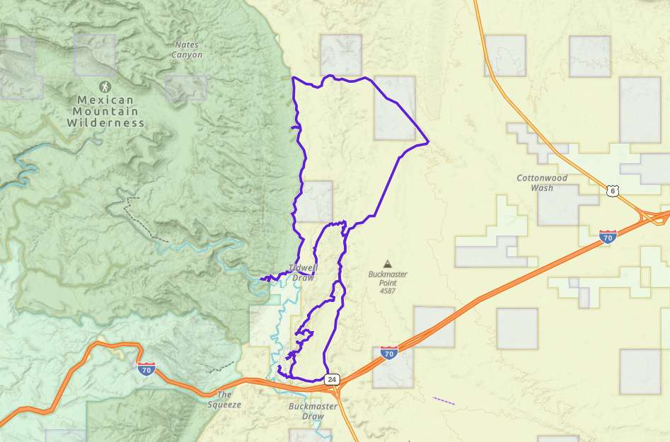
Trail Route

We recommend to download the GAIA App on your mobile device.
You can view and download the route from GAIA as well as see photos with their location geotagged on the trail.
360 Street View
Click “View 360 Map” to explore the trail in Google Street View and “See the Trail Before You Ride the Trail.”
Download Route
The GPX or KML files are available for you to download and use on your preferred app or device.
Key Points
Within our Key Points you will discover trail head parking, trail markers, points of interests, intersections as well as terrain and obstacles.
Click on the links below to reveal images and information
The trail exits the parking area to the South West.
Starting to climb up into the ledges
We quickly climb up to an overlook of the San Rafael River and the iconic upthrust rock formations that mark the entrance to the San Rafael Swell. Zoom in a bit and you can see I-70 as it disappears into the rock.
This is what it looks like when you simply follow the tracks in the sand and find yourself making a very scenic U-Turn.
The trail attempts to camouflage itself here as it climbs the solid rock slope to the left. We zipped right past it and had to return.
It seems that leaving your vehicle on the Buckmaster for 50 years has some consequences.
You can turn left here, but we didn’t get very far before the washed out trail stopped us.
Maybe a little Trail Cat work is in order? Or a LOT.
Remnants of the mining era are still visible in lots of old cabins, abandoned mining equipment, and occasional open mines. Be careful.
More Abandoned buildings.
The view of the valley from a few miles further north.
This well-maintained gravel road will lead you right back to the trailhead, bear right.


