Facilities
  OHVs
OHVs Terrain
 Signage
 Emergencies Facilities
 There are a few motels out of Big Water, Utah and fuel toward Page, AZ. You can stock up on fuel and groceries in Kanab.
OHVsAll sizes. No width limits. ATVs, MCs, UTVs, 4x4s on most trails.
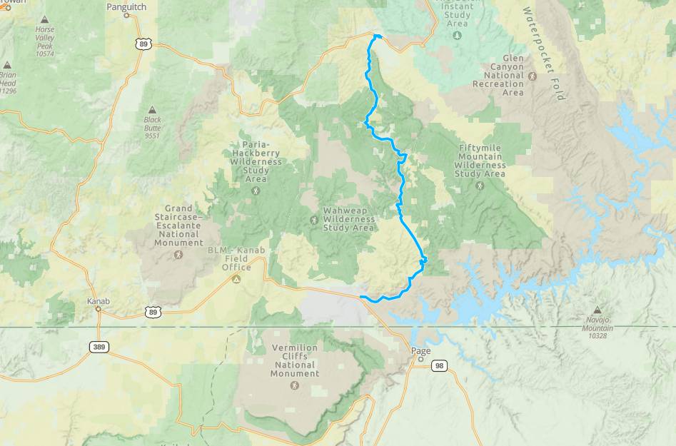
TerrainGravel and dirt roads.
SignageMost trails have adequate signage. We recommend sticking to Smoky Mountain Road (graded road)
EmergenciesThe closest medical help is the hospital in Page AZ, 501 N Navajo Drive Road. Open 24 hours (928) 645-2424. Or the Kazan Memorial Clinic out of Escalante, 570 East Moqui Lane, Escalante, UT 84726 (435) 826-4374
Kane County Sheriff: Dial 9-1-1 for emergencies or Non-Emergency Dispatch: (435) 644-2349
Garfield County Sheriff: Dial 9-1-1 for emergencies or Non-Emergency (435) 676-2678
Utah Highway Patrol: Dial 9-1-1
We highly recommend you purchase a Utah Search and Rescue Assistant Card (USARA) learn more: gcutsheriff.com
There are a few motels out of Big Water, Utah and fuel toward Page, AZ. You can stock up on fuel and groceries in Kanab.
All sizes. No width limits. ATVs, MCs, UTVs, 4x4s on most trails.
Gravel and dirt roads.
Most trails have adequate signage. We recommend sticking to Smoky Mountain Road (graded road)
The closest medical help is the hospital in Page AZ, 501 N Navajo Drive Road. Open 24 hours (928) 645-2424. Or the Kazan Memorial Clinic out of Escalante, 570 East Moqui Lane, Escalante, UT 84726 (435) 826-4374
Kane County Sheriff: Dial 9-1-1 for emergencies or Non-Emergency Dispatch: (435) 644-2349
Garfield County Sheriff: Dial 9-1-1 for emergencies or Non-Emergency (435) 676-2678
Utah Highway Patrol: Dial 9-1-1
We highly recommend you purchase a Utah Search and Rescue Assistant Card (USARA) learn more: gcutsheriff.com