Facilities
  OHVs
OHVs Terrain
 Signage
 Emergencies Facilities
 With Blanding as a base camp, there are: 6 motels, a handful of Airbnb stops, 2 RV parks, a campground, 8 dining options, 2 Grocery stores and 4 Gas Stations. Additional amenities can found down the road 26 miles in Bluff.
OHVsThis trail is open to all types of off road vehicles. Standard clearance vehicles should be able to navigate this trip, but 4WD is strongly recommended due to sand. And stream bed crossings.
TerrainMostly compacted sand, but some desert dirt. This trail follows the bottom of a deep canyon and crosses the stream in the bottom many times so the difficulty of this trail may depend on how severe recent weather has affected water flow.
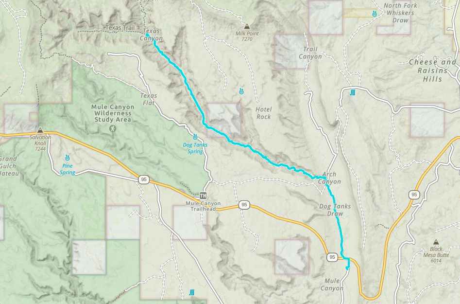
SignageWhile there are not many route marker signs there are few options along the route to get very lost. Particularly near the beginning of the trail where it begins to follow the stream bed into arch canyon. Clearly many drivers have been confused in this area and there are a few dead end routes in the immediate area. The route is not well marked, so while there aren’t many options it is best to have a map or download the route to your GPS app. Watch carefully for the hard turn to the west as you cross the stream bed at the east end of arch canyon near the beginning. Don’t worry if you get lost, it will only be for a few minutes and you will quickly find yourself backtracking and finding the trail.
EmergenciesClosest Medical Facilities Blue Mountain Hospital (435) 678-3993
Utah Highway Patrol Dial 9-1-1
Bureau of Land Management: (435) 587-1500
San Juan County Sheriff: (435) 587-2237
Utah Highway Patrol Dial 9-1-1
Bureau of Land Management: (435) 587-1500
San Juan County Sheriff: (435) 587-2237
With Blanding as a base camp, there are: 6 motels, a handful of Airbnb stops, 2 RV parks, a campground, 8 dining options, 2 Grocery stores and 4 Gas Stations. Additional amenities can found down the road 26 miles in Bluff.
This trail is open to all types of off road vehicles. Standard clearance vehicles should be able to navigate this trip, but 4WD is strongly recommended due to sand. And stream bed crossings.
Mostly compacted sand, but some desert dirt. This trail follows the bottom of a deep canyon and crosses the stream in the bottom many times so the difficulty of this trail may depend on how severe recent weather has affected water flow.
While there are not many route marker signs there are few options along the route to get very lost. Particularly near the beginning of the trail where it begins to follow the stream bed into arch canyon. Clearly many drivers have been confused in this area and there are a few dead end routes in the immediate area. The route is not well marked, so while there aren’t many options it is best to have a map or download the route to your GPS app. Watch carefully for the hard turn to the west as you cross the stream bed at the east end of arch canyon near the beginning. Don’t worry if you get lost, it will only be for a few minutes and you will quickly find yourself backtracking and finding the trail.
Closest Medical Facilities Blue Mountain Hospital (435) 678-3993
Utah Highway Patrol Dial 9-1-1
Bureau of Land Management: (435) 587-1500
San Juan County Sheriff: (435) 587-2237
Utah Highway Patrol Dial 9-1-1
Bureau of Land Management: (435) 587-1500
San Juan County Sheriff: (435) 587-2237