Arapeen OHV Trail: Manti Loop
- Sanpete County - Manti
Menu
Trail information
Easy
Loop Trail
No width limit
Dirt Trail
graded roads
Single Track
50" Vehicle
S x S
Full Size
Moving Time
0
hrs
Avg Speed
0
mph
Distance
0
mi
Ascent
0
ft
Descent
0
ft
Lodging, camping, groceries, restaurants, entertainment and fuel can all be found in Manti before leaving. Restrooms can be found at Patton Trailhead and Yearns Reservoir.
ATVs, MCs, UTVs, 4x4s all sizes on most trails (depending on the section there are some restrictions to 66″).
Mostly Graded Roads | US Forest Service rates this trail as More Difficult.
The main routes have adequate signage. There are a number of side roads so the GPS becomes helpful. You will be sticking to the Patton Trailhead (Arapeen Route 3) for most of the ride.
The closest medical help is Gunnison Valley Hospital, 64 E 100 N Street, Gunnison, UT 84634. (435) 528-7246.
Dial 9-1-1 for emergencies.
Sanpete County Sheriff: Dial 9-1-1 or (435) 835-2191. 1500 S Hwy 89, Manti, UT 84642
Utah Highway Patrol: Dial 9-1-1
We highly recommend you purchase a Utah Search and Rescue Assistant Card (USARA), learn more: utah.gov/rescue
Dial 9-1-1 for emergencies.
Sanpete County Sheriff: Dial 9-1-1 or (435) 835-2191. 1500 S Hwy 89, Manti, UT 84642
Utah Highway Patrol: Dial 9-1-1
We highly recommend you purchase a Utah Search and Rescue Assistant Card (USARA), learn more: utah.gov/rescue
- trail weather
Weather Forecast Info can´t be read at the moment!
- Description
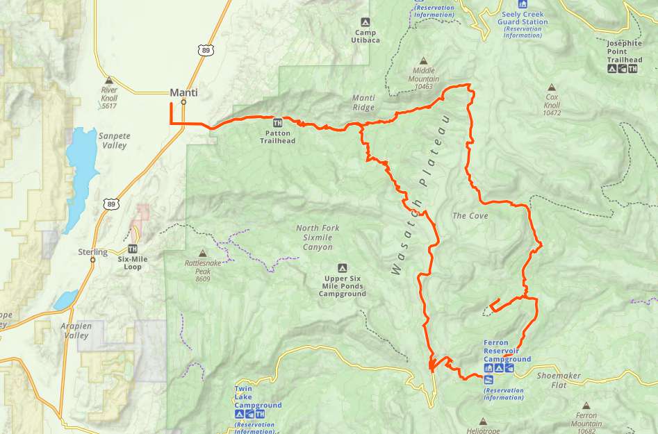
The Manti Loop Trail is a 55 mile trip that took us 5 hours at average 10.5 mph; leaving from the Manti City Park. The trail starts at the Patton Trailhead and goes through the Manti Community Campground, Yearns Reservoir, Middle Fork Manti Canyon, Loggers Fork, Loggers Reservoir, Jet Fox Reservoir, Cove Lake, Duck Fork Reservoir, Ferron Reservoir and onto the Sky Line Drive. Plan this trip as a light full day ride that leaves time to explore all the canyons, reservoirs and nearby Manti.
Maps
Trail Route

We recommend to download the GAIA App on your mobile device.
You can view and download the route from GAIA as well as see photos with their location geotagged on the trail.
360 Street View
Click “View 360 Map” to explore the trail in Google Street View and “See the Trail Before You Ride the Trail.”
Download Route
The GPX or KML files are available for you to download and use on your preferred app or device.
Key Points
Within our Key Points you will discover trail head parking, trail markers, points of interests, intersections as well as terrain and obstacles.
Click on the links below to reveal images and information
Start in Manti City Park. Head south on N 400 W Street toward First N. Turn left at the first cross street onto First N. And then turn right onto N Main St. until you come to 400 S. Then turn left onto E 400 S. Next turn right onto 400 E St. Then you will turn left onto E 500 S St. Continue onto Manti Canyon Road to Patton Trailhead.
Yearns Reservoir (restrooms available).
Continue east on FR0045.
Stay to the right on FR0046 heading east.
Stay to the right heading north.
Stay to the left heading east.
Here’s a beautiful view of the valley below.
Stay to the left to head south.
Take the third road to the right and head between the opening in the fence heading to Blue Lake and Cove Creek.
Another sampling of things to see on the trail (Cove Lake).
Turn right to go to Duck Creek Reservoir. You will need to come back this way and continue straight or to the left to continue the Manti Loop.
Duck Creek Reservoir (restrooms available).
Stay to the left heading south toward Ferron Reservoir.
Ferron Reservoir. Stay to the right heading south at the fork. You will now be on the Sky Line Drive.
Beautiful valley view.
Stay to the right heading west on Sky Line Drive.
Stay to the left heading toward Manti. You will now be leaving Sky Line Drive and heading back to the start of the loop.


