Ute Mountain
- Daggett County - Manila
Menu
Trail information
Easy
Out & Back
No width limit
Dirt Trail
Sand Trail
Single Track
50" Vehicle
S x S
Full Size
Moving Time
0
hrs
Avg Speed
0
mph
Distance
0
mi
Ascent
0
ft
Descent
0
ft
Lodging, camping, fuel and supplies are all available in nearby Manila; primitive camping and vault toilet available along the trail
Some width limits. ATVs, MCs, UTVs, 4x4s on most trails. Some trailheads are exclusive to non-motorized. Please pay attention to signs and stay on the trail.
Mostly graded county toads; some 50″ ATV trails
The trails in this area are well marked with additional kiosks and information placards at points of interest.
The closest medical help is Ashley Regional Medical Center, 150 W 100 N, Vernal, UT 84078. Dial 9-1-1 for emergencies or (435) 789-3342
Daggett County Sheriff’s Office: Dial 9-1-1 for emergencies or (435) 784-3255
Utah Highway Patrol: Dial 9-1-1
Ashley National Forest: 355 North Vernal Avenue Vernal, UT 84078 (435) 789-1181
We highly recommend you purchase a Utah Search and Rescue Assistant Card (USARA), learn more: utah.gov/rescue
Daggett County Sheriff’s Office: Dial 9-1-1 for emergencies or (435) 784-3255
Utah Highway Patrol: Dial 9-1-1
Ashley National Forest: 355 North Vernal Avenue Vernal, UT 84078 (435) 789-1181
We highly recommend you purchase a Utah Search and Rescue Assistant Card (USARA), learn more: utah.gov/rescue
- trail weather
Weather Forecast Info can´t be read at the moment!
- Description
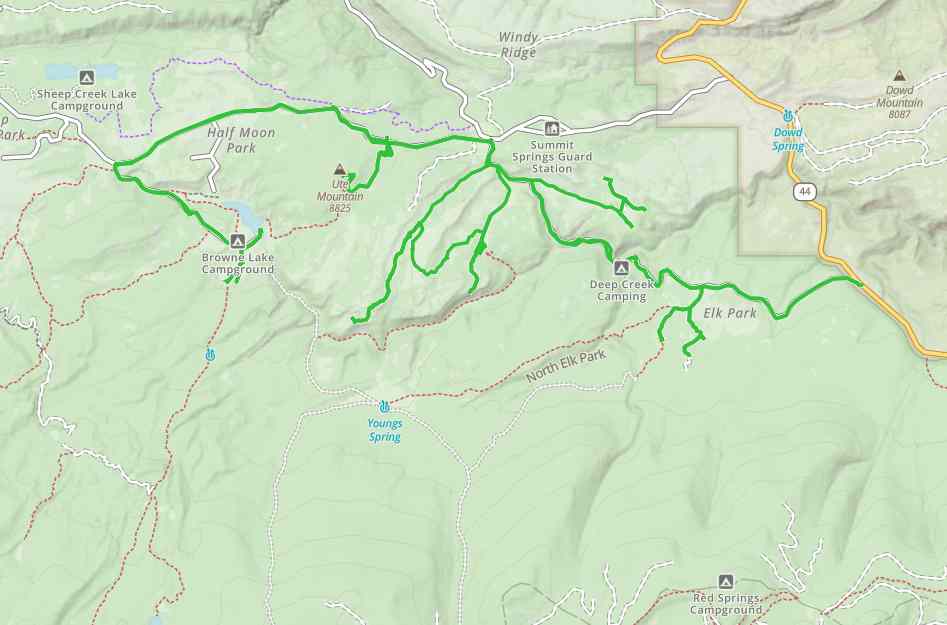
Ute Mountain OHV Trail will take you to the last standing fire tower with a living quarters in Utah. The trailhead is right off the highway UT-44, 20 minutes south of Manila, Utah. We road 50 miles on the trail in about five hours at an average speed of 10 mph. Our first stop was the Ute Mountain Fire Tower but there are a number of side trails and areas to explore in the surrounding area, read our remarks below and take a 360 view of the trail to see some of our stops. The trail offers great views of the High Uintahs and is close to Flaming Gorge.
Maps
Trail Route

We recommend to download the GAIA App on your mobile device.
You can view and download the route from GAIA as well as see photos with their location geotagged on the trail.
360 Street View
Click “View 360 Map” to explore the trail in Google Street View and “See the Trail Before You Ride the Trail.”
Download Route
The GPX or KML files are available for you to download and use on your preferred app or device.
Key Points
Within our Key Points you will discover trail head parking, trail markers, points of interests, intersections as well as terrain and obstacles.
Click on the links below to reveal images and information
This is the trailhead there is some parking and space to unload just off the highway.
Stay right at the sign for Elk Park Trails 013 & 014 heading west. We will visit this point later in the ride.
Continue heading west. The Deep Creek Campground is to the right. There are some good camp spots up the loop as well as a vault toilet. Find out more here: usda.gov
Turning left will take you on the trail to the Ute Mountain Fire Watch Tower.
This is a cool stop. The Ute Mountain Fire Lookout was the first and remains as the last tower with living quarters in Utah. Learn more about this site: usda.gov/detail
Stay heading west. There is a pull off to the right and a trailhead for another ATV trail (route 166).
Cruising past Half Moon Park. Keep an eye out for wildlife.
Turn left here to head south.
Beaver Cr. – Weyman Park Trail
Browne Lake. There is also a campground nearby (Browne Lake Campground), but we were a little late in the season so the gates were locked. More info: usda.gov/recarea/ashley/
We found hiking trailheads for Tepee Lake, Red Lake, Leidy Peak, Lost Lake Trail and Lost Lake at the end of this trail.
Carter Creek is just over the ridge. Carter Creek runs right into Flaming Gorge and offers some amazing fly fishing.
On the way back, we took this side road out to Scraper Spring and Elk Park.


