Facilities
  OHVs
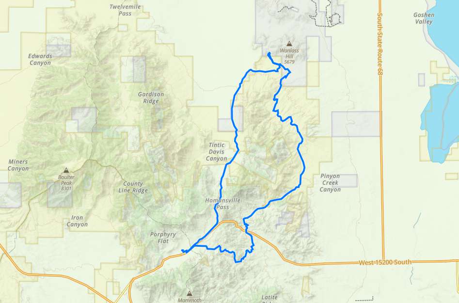
OHVs Terrain
 Signage
 Emergencies Facilities
 Eureka has Fuel, a few Restaurants and some Air B&B’s but no Hotels.
OHVsAny size vehicle will do well on this trail.
TerrainMost of the trail is smooth dirt road, the “Little Moab” area is well known to have some serious rock crawling but you can easily pick and choose to fit your machine and experience level and even avoid the large obstacles all together if you prefer.
SignageThere are a few trail signs as part of the Chief Tintic Trail system but this trail does not follow any particular numbered trail so get the GPS track.
EmergenciesThe closest medical help is the
SANTAQUIN CLINIC
Address
210 East Main Street
Santaquin, UT 84655
The closest Hospital is
Mountain View Hospital Payson
Address
1000 E 100 N, Payson, UT 84651
(801) 465-7000
Dial 9-1-1 for emergencies.
Juab County Sheriff: Dial 9-1-1 or (435) 623-1344 for non emergencies. 425 West Sheeplane Drive, Nephi, UT 84648
Utah Highway Patrol: Dial 9-1-1
We highly recommend you purchase a Utah Search and Rescue Assistant Card (USARA), learn more: utah.gov/rescue
Eureka has Fuel, a few Restaurants and some Air B&B’s but no Hotels.
Any size vehicle will do well on this trail.
Most of the trail is smooth dirt road, the “Little Moab” area is well known to have some serious rock crawling but you can easily pick and choose to fit your machine and experience level and even avoid the large obstacles all together if you prefer.
There are a few trail signs as part of the Chief Tintic Trail system but this trail does not follow any particular numbered trail so get the GPS track.
The closest medical help is the
SANTAQUIN CLINIC
Address
210 East Main Street
Santaquin, UT 84655
The closest Hospital is
Mountain View Hospital Payson
Address
1000 E 100 N, Payson, UT 84651
(801) 465-7000
Dial 9-1-1 for emergencies.
Juab County Sheriff: Dial 9-1-1 or (435) 623-1344 for non emergencies. 425 West Sheeplane Drive, Nephi, UT 84648
Utah Highway Patrol: Dial 9-1-1
We highly recommend you purchase a Utah Search and Rescue Assistant Card (USARA), learn more: utah.gov/rescue