Daniels Summit
- Wasatch County - Heber City
Menu
Trail information
Easy
Loop Trail
No width limit
Dirt Trail
rocky Trail
Single Track
50" Vehicle
S x S
Full Size
Moving Time
0
hrs
Avg Speed
0
mph
Distance
0
mi
Lodging, camping, fuel and supplies are all available in nearby Heber with additional amenities at the Daniels Summit Lodge. Click here to learn more about their offerings.
All sizes. No width limits. ATVs, MCs, UTVs, 4x4s on most trails.
Mostly dirt and rocky roads.
Most trails have adequate signage.
The closest medical help is the Heber Valley Hospital, 454 East Medical Way, Heber City, UT 84032. (435) 654-2500 or Uintah Basin Medical Center, 250 W 300 N, Roosevelt, UT 84066 (435) 722-4691
Wasatch County Sheriff: Dial 9-1-1 for emergencies or non-emergency dispatch: (435) 654-1411
Utah Highway Patrol: Dial 9-1-1
Wasatch County Sheriff: Dial 9-1-1 for emergencies or non-emergency dispatch: (435) 654-1411
Utah Highway Patrol: Dial 9-1-1
- trail weather
Weather Forecast Info can´t be read at the moment!
- Description
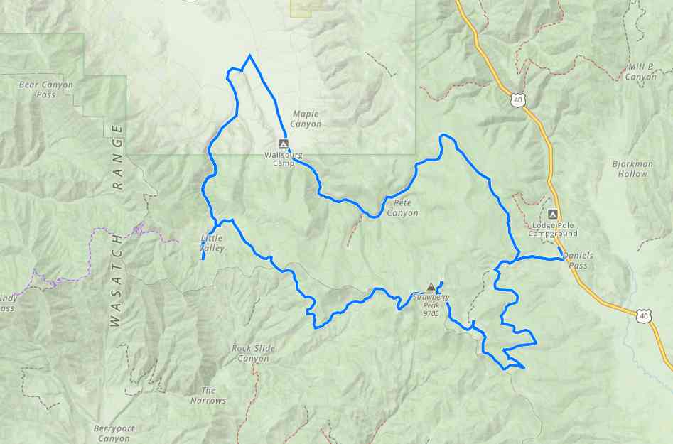
The Daniels Summit OHV Loop is 45 miles of riding in the Uinta National Forest. Our ride took approximately 6 hours at 7 mph. This is a full-day ride that will take you west of Daniels Summit Lodge toward Wallsburg. The trail winds itself through quaking aspen, conifers and scrub oak in a loop. The trailhead is about 20 minutes outside Heber City off the main highway starting from the Daniels Summit Lodge.
Daniels Summit serves as a perfect base camp for your adventure offering lodging, dining, a general store and rentals. Nearby Heber is a good place to stock up on fuel and supplies before heading up the canyon.
Daniels Summit serves as a perfect base camp for your adventure offering lodging, dining, a general store and rentals. Nearby Heber is a good place to stock up on fuel and supplies before heading up the canyon.
Maps
Trail Route

We recommend to download the GAIA App on your mobile device.
You can view and download the route from GAIA as well as see photos with their location geotagged on the trail.
360 Street View
Click “View 360 Map” to explore the trail in Google Street View and “See the Trail Before You Ride the Trail.”
Download Route
The GPX or KML files are available for you to download and use on your preferred app or device.
Key Points
Within our Key Points you will discover trail head parking, trail markers, points of interests, intersections as well as terrain and obstacles.
Click on the links below to reveal images and information
You can access the Daniels Summit loop from Daniels Summit Lodge just of highway 40, 20 minutes outside of Heber, Utah. There is a general store, lodging and rentals available at the trailhead.
Turn right onto the Daniels Summit Loop heading north. Continue driving along route 046.
The fall is a great time to go on this ride if you time your trip to the fall colors. We rode the trail in early October.
You will pop out onto some pavement just southeast of Wallsburg. Take a left heading south on Little Valley Road.
Continuing past some private property you will come to a sign indicating the road may be impassable due to snow or inclement weather.
Stay right at the water crossing and cross carefully. This is a segment of trail that has become braided.
We went west on this trail that runs through a grove of quaking aspen. It’s a little ways off the loop but is a good place to stop for lunch.
Turn right at this cross roads to head south.
This was a segment of trail that was more gnarly than the rest with a couple larger rocks to bump over.
Views from the trail out across the valley. This is a good example of the riding you will find along this trail.
Turn right to stay on route 135. If you look to the west you can see Strawberry Peak.


