Collet Top Loop OHV Trail

Trail information

Easy

Loop Trail

No width limit

Dirt Trail

gravel roads

Single Track

50" Vehicle

S x S

Full Size

0 hrs
Moving Time
0 mph
Avg Speed
0 mi
Distance
0 ft
Ascent
0 ft
Descent
Lodging, restaurants, fuel and groceries are all available in Escalante, Utah. Staging can be done from the town of Escalante. The trail stretches to very remote areas so don’t count on facilities once you depart.
All sizes. No width limits. ATVs, MCs, UTVs, 4x4s on most trails.
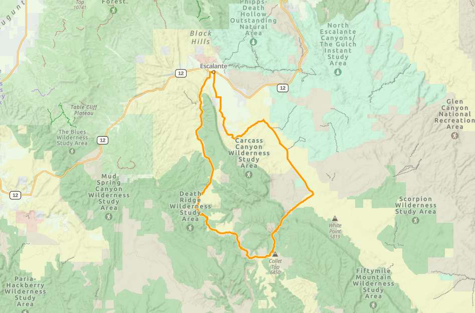
Dirt and gravel roads, desert washes that are dry in the summer, wet in spring, and frozen over in winter.
Signage for main roads and distances. Minimal signage for points of interest.
The closest medical help is Kazan Memorial Clinic in Escalante – 570 East Moqui Lane, Escalante, UT 84726 Open 9AM-5PM Closed Saturday and Sunday. Closest hospital is the Garfield Memorial Hospital in Panguitch – 200 N 400 E St, Panguitch, UT 84759 Emergency room open 24 hours a day.
Garfield County Sheriff: Dial 9-1-1 for emergencies or Non-Emergency Dispatch: 435-676-2678. Utah Highway Patrol: Dial 9-1-1.
We highly recommend you purchase a Utah Search and Rescue Assistant Card (USARA) learn more: utah.gov/rescue
The Collet Top Loop is an intermediate ride south of the town of Escalante in the Grand Staircase-Escalante National Monument. This is an all day ride that takes you almost 73 miles in about six hours of drive time.

The trail follows a few different BLM Routes including BLM 200, 230 and 300. These routes take you through areas of Cedar Wash, Hole-in-the-Rock Road and Collet Top.

The ride features mostly maintained dirt roads, but the road can get a little rough while traveling through the washes located at the bottoms of canyons.

Throughout the ride you’re greeted by amazing geological structures the monument is known for, as well as some archaelogical sites as well. There are opportunities for short hikes through the trail that treat you to points of interest, including the Cedar Wash Arch, and Twenty Mile Dinosaur Tracks.

There is plenty of lodging in and just outside of the town of Escalante. The town has every necessity between grocers and gas stations. There is also opportunity for primitive camping along Hole-in-the-Rock Road.

Prepare adequately for each season. The area is very hot and dry during the summer, so extra water is highly recommended. During the winter the washes can get wet or even frozen over. Drive cautiously through these areas. Flash flooding is also a possibility. Keep an eye on the weather.

Overall the Collet Top Loop offers something for everyone and would be fun an experienced driver to bring their whole family.
Maps

Trail Route

Collet Top Loop gaia

We recommend to download the GAIA App on your mobile device.

You can view and download the route from GAIA as well as see photos with their location geotagged on the trail.

360 Street View

Click “View 360 Map” to explore the trail in Google Street View and “See the Trail Before You Ride the Trail.”

Flyover Map

 Experience a bird’s-eye view of the trail to get a better understanding of elevation changes and the surrounding terrain.

Download Route

The GPX or KML files are available for you to download and use on your preferred app or device. 

Key Points

Within our Key Points you will discover trail head parking, trail markers, points of interests, intersections as well as terrain and obstacles.

Click on the links below to reveal images and information

You can start this trail off from the Escalante City Park if you have a street legal machine. Head south on Center Street until you hit dirt road.
The “official” beginning of Cedar Wash Road.
If you would like to detour to the Cedar Wash Arch viewpoint, take a right at this fork, otherwise stay left to head to the rest of the trail.
Sign for the Devil’s Garden day use area. This spot has beautiful hoodoos, picnic tables and bathrooms if needed.
Right hand turn for dinosaur tracks, straight to continue the trail.
Be cautious through these washes, they can be muddy, frozen over or prone to flash floods.
The bottom of this wash is home to some striking structures like this balancing rock.
Beautiful views at the top of the switchback.
There is a small archaeological site near this intersection if you keep your eyes peeled. Remember: Look, but don’t touch!
The rest of the trail will be following the BLM 300 route the rest of the way back to Escalante. This is about the halfway point!
Be careful rolling through washes like these. These are dangerous spots for flash floods.
More beautiful views along the trail.
The rest of the way back to Escalante is driving through washes intermittently. Great views the whole way.
trail video
Share The Trail
Facebook
Twitter
LinkedIn
Email
WhatsApp
comments
0.0
Rated 0.0 out of 5
0.0 out of 5 stars (based on 0 reviews)
Excellent0%
Very good0%
Average0%
Below Average0%
Poor0%

There are no comments yet be the first to write one :)

Related Trails

We add new trails every week!

Receive the latest trails, as well as updates on outdoor recreation and off-road events in Utah.
Join our community!

small_c_popup.png

Thank You For Joining Outsiders!!