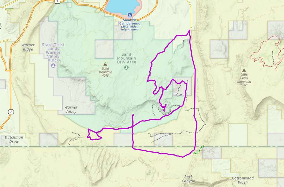
Hurricane Valley South

Trail information

Easy

Loop Trail

No width limit

rocky

Sand Trail

Single Track

50" Vehicle

S x S

Full Size

0 hrs
Moving Time
0 mph
Avg Speed
0 mi
Distance
0 ft
Ascent
0 ft
Descent
Lodging, restaurants, fuel and groceries are available in the town of Washington.
Mostly OHV trail-style riding.
Mostly sand trails – some rocky areas. Mostly OHV trail-style riding.
signs at most intersections noting distance to landmarks and direction of travel.
St. George Regional Hospital River Road Emergency Department – 1380 E Medical Center Dr, St George, UT.
Washington Police Department: Dial 9-1-1 for emergencies or Non-Emergency Dispatch: 435-986-1515.
We highly recommend you purchase a Utah Search and Rescue Assistant Card (USARA) learn more: utah.gov/rescue
The Hurricane Valley South trail is a great trail for exploring some of beautiful Southern Utah. This ride will take you on cliffside overlooks and through desert valleys. You have the opportunity to check out a couple of landmarks in the area. The first one is Fort Pearce. This fort was built by settlers in the 1800s to protect them from Navajo Native Americans during the Black Hawk war. The second is the Dinosaur Track Site. With just a short walk you are able to walk where the dinosaurs used to roam and see their footprints in the rock.

The terrain is mostly comprised of dirt and rocky trails.

This trail provides great opportunities to stop, get out and take in the views.

You can also find just about every amenity you need in town including gas, lodging and food.
Maps

Trail Route

Hurricane Valley South gaiacc

We recommend to download the GAIA App on your mobile device.

You can view and download the route from GAIA as well as see photos with their location geotagged on the trail.

360 Street View

Click “View 360 Map” to explore the trail in Google Street View and “See the Trail Before You Ride the Trail.”

Flyover Map

 Experience a bird’s-eye view of the trail to get a better understanding of elevation changes and the surrounding terrain.

Download Route

The GPX or KML files are available for you to download and use on your preferred app or device. 

Key Points

Within our Key Points you will discover trail head parking, trail markers, points of interests, intersections as well as terrain and obstacles.

Click on the links below to reveal images and information

You can find ample parking here in this lot a ways south of Hurricane.
There are a few signs indicating which direction to go for specific trails. We head off to the right here.
The terrain is mostly dirt with a few rocky areas like this.
This section of the trail brings you up on this cliffside with beautiful views. However, be aware that the old road was damaged so it is a bit of a dead end.
One of the interesting things to check out on this ride is Fort Pearce. This fort was built by settlers in the 1800s to protect them from Navajo Native Americans during the Black Hawk war.
Another thing worth checking out is the Warner Valley Dinosaur Tracks. With just a short walk you’re able to see dinosaur footprints in the rocks in this area.
We ended the ride on a well maintained road through this beautiful valley.
trail video

Coming Soon!

Share The Trail
Facebook
Twitter
LinkedIn
Email
WhatsApp
comments
0.0
Rated 0.0 out of 5
0.0 out of 5 stars (based on 0 reviews)
Excellent0%
Very good0%
Average0%
Below Average0%
Poor0%

There are no comments yet be the first to write one :)

Related Trails

We add new trails every week!

Receive the latest trails, as well as updates on outdoor recreation and off-road events in Utah.
Join our community!

small_c_popup.png

Thank You For Joining Outsiders!!