Facilities
  OHVs
OHVs Terrain
 Signage
 Emergencies Facilities
 Lodging, restaurants, fuel and groceries can all be found in the town of Tropic. Similar services can be found east in Escalante, and to the west in Bryce. There are no facilities on the trail.
OHVsAll sizes. No width limits. ATVs, MCs, UTVs, 4x4s on most trails.
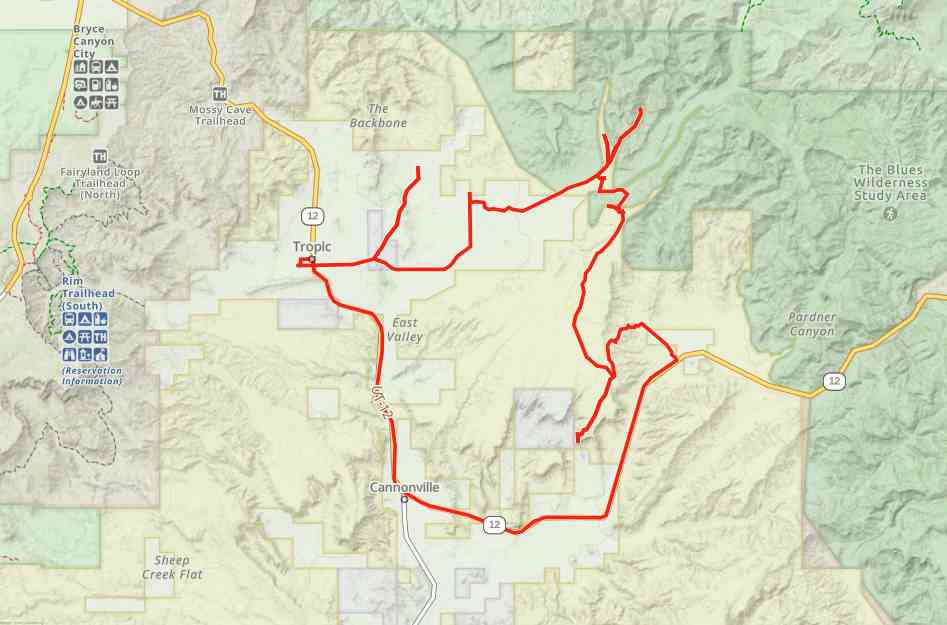
TerrainMostly dirt and gravel roads. Wash crossing at a few points.
SignageTrail is well signed including signs for offshoot trails and wilderness areas.
EmergenciesGarfield Memorial Hospital Emergency Department at 200 N 400 E St, Panguitch, UT 84759 (435) 676-8811. Open 24 hours
Garfield County Sheriff: Dial 9-1-1 for emergencies or Non-Emergency (435) 676-2678; Utah Highway Patrol: Dial 9-1-1
We highly recommend you purchase a Utah Search and Rescue Assistant Card (USARA) learn more: utah.gov/rescu
Garfield County Sheriff: Dial 9-1-1 for emergencies or Non-Emergency (435) 676-2678; Utah Highway Patrol: Dial 9-1-1
We highly recommend you purchase a Utah Search and Rescue Assistant Card (USARA) learn more: utah.gov/rescu
Lodging, restaurants, fuel and groceries can all be found in the town of Tropic. Similar services can be found east in Escalante, and to the west in Bryce. There are no facilities on the trail.
All sizes. No width limits. ATVs, MCs, UTVs, 4x4s on most trails.
Mostly dirt and gravel roads. Wash crossing at a few points.
Trail is well signed including signs for offshoot trails and wilderness areas.
Garfield Memorial Hospital Emergency Department at 200 N 400 E St, Panguitch, UT 84759 (435) 676-8811. Open 24 hours
Garfield County Sheriff: Dial 9-1-1 for emergencies or Non-Emergency (435) 676-2678; Utah Highway Patrol: Dial 9-1-1
We highly recommend you purchase a Utah Search and Rescue Assistant Card (USARA) learn more: utah.gov/rescu
Garfield County Sheriff: Dial 9-1-1 for emergencies or Non-Emergency (435) 676-2678; Utah Highway Patrol: Dial 9-1-1
We highly recommend you purchase a Utah Search and Rescue Assistant Card (USARA) learn more: utah.gov/rescu