Facilities
  OHVs
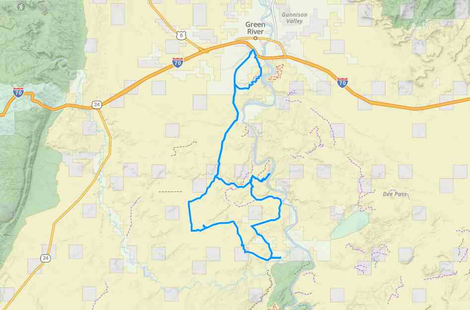
OHVs Terrain
 Signage
 Emergencies Facilities
 Lodging, restaurants, fuel and groceries are all available in Green River. There are no services or rest stops on the trail.
OHVsAll sizes. No width limits. ATVs, MCs, UTVs, 4x4s on most trails.
TerrainIntermediate – Mostly graded county roads with some more technical riding in wash bottoms and sand.
SignageMost trails have adequate signage but this is a good one to use your GPS on (see below).
EmergenciesThe closest medical help is Green River Medical Center, 585 Main Street, Green River, UT 84525. Dial 9-1-1 for emergencies or (435) 564-3434. If a hospital is required, Castleview Hospital is in Price. 300 North Hospital Drive, Price, UT 84501. Open 24 hours (435) 637-4800
Emery County Sheriff – Green River: Dial 9-1-1 or (435) 381-2404; Utah Highway Patrol – Green River: Dial 9-1-1 or (435) 564-3474. BLM Office – Price: (435) 636-3600. We highly recommend you purchase a Utah Search and Rescue Assistant Card (USARA), learn more: utah.gov/rescue
Emery County Sheriff – Green River: Dial 9-1-1 or (435) 381-2404; Utah Highway Patrol – Green River: Dial 9-1-1 or (435) 564-3474. BLM Office – Price: (435) 636-3600. We highly recommend you purchase a Utah Search and Rescue Assistant Card (USARA), learn more: utah.gov/rescue
Lodging, restaurants, fuel and groceries are all available in Green River. There are no services or rest stops on the trail.
All sizes. No width limits. ATVs, MCs, UTVs, 4x4s on most trails.
Intermediate – Mostly graded county roads with some more technical riding in wash bottoms and sand.
Most trails have adequate signage but this is a good one to use your GPS on (see below).
The closest medical help is Green River Medical Center, 585 Main Street, Green River, UT 84525. Dial 9-1-1 for emergencies or (435) 564-3434. If a hospital is required, Castleview Hospital is in Price. 300 North Hospital Drive, Price, UT 84501. Open 24 hours (435) 637-4800
Emery County Sheriff – Green River: Dial 9-1-1 or (435) 381-2404; Utah Highway Patrol – Green River: Dial 9-1-1 or (435) 564-3474. BLM Office – Price: (435) 636-3600. We highly recommend you purchase a Utah Search and Rescue Assistant Card (USARA), learn more: utah.gov/rescue
Emery County Sheriff – Green River: Dial 9-1-1 or (435) 381-2404; Utah Highway Patrol – Green River: Dial 9-1-1 or (435) 564-3474. BLM Office – Price: (435) 636-3600. We highly recommend you purchase a Utah Search and Rescue Assistant Card (USARA), learn more: utah.gov/rescue