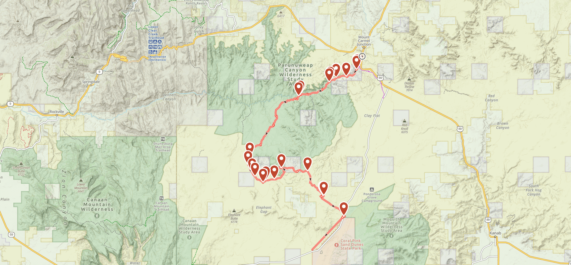
The Barracks Trail

Trail information

Easy

Out & Back

No width limit

Dirt Trail

Sand Trail

Single Track

50" Vehicle

S x S

Full Size

0 hrs
Moving Time
0 mph
Avg Speed
0 mi
Distance
0 ft
Ascent
0 ft
Descent
Lodging, restaurants, fuel and groceries are available in the town of Mount Carmel Junction or Kanab.
Mostly OHV trail-style riding.
Mostly dirt and sand trails – some rocky areas. Mostly OHV trail-style riding.
signs at most intersections noting distance to landmarks and direction of travel.
Emergencies: Kane County Hospital: 355 N. Main, Kanab, UT 84741.
Kanab Police Department: Dial 9-1-1 for emergencies or Non-Emergency Dispatch: 435-644-5854. We highly recommend you purchase a Utah Search and Rescue Assistant Card (USARA) learn more: utah.gov/rescue
The Barracks Trail in Kane County is a great trail to explore and familiarize yourself with the Mount Carmel Junction Area trails. This trail takes you about 27 miles through the gorgeous landscape of Southern Utah. We started off just South of the town of Mount Carmel Junction and ended the ride right next to Coral Pink Sand Dunes State Park. While this ride will only take you about 3.5 hours (moving time), there are camping sites along the trail if you wanted to spend more time riding trails in the area. There is a lot of beauty in this area.

You can expect to be driving on mostly dirt roads. Depending on the time of year you ride this trail, you may run into some water and snow.

This trail provides great opportunities to stop, get out, and take in the views.

You can also find just about every amenity you need including gas, lodging, and food in the town of Mount Carmel Junction or Kanab.
Maps

Trail Route

the barracks

We recommend to download the GAIA App on your mobile device.

You can view and download the route from GAIA as well as see photos with their location geotagged on the trail.

360 Street View

Click “View 360 Map” to explore the trail in Google Street View and “See the Trail Before You Ride the Trail.”

Flyover Map

 Experience a bird’s-eye view of the trail to get a better understanding of elevation changes and the surrounding terrain.

Download Route

The GPX or KML files are available for you to download and use on your preferred app or device. 

Key Points

Within our Key Points you will discover trail head parking, trail markers, points of interests, intersections as well as terrain and obstacles.

Click on the links below to reveal images and information

We started our ride here at this pull off just off Highway 89 South of Mt. Carmel Junction. There is a good amount of parking and the trail takes off just across the highway.

There are several campgrounds along the way if you wanted to spend multiple days riding trails in this area.

The trail takes off to the left here. Portions of the trail cut through private property. While this is allowed, be sure to be extra respectful in these areas.

Depending on the time of year you ride this trail, you may end up riding through some water, mud, and snow.

The trail is mostly dirt roads, however there are some sections of slick rock as you can see here.

The trail takes us right to Coral Pink Sand Dunes State Park – another really great place to explore if you haven’t yet.

trail video
Share The Trail
Facebook
Twitter
LinkedIn
Email
WhatsApp
comments
0.0
Rated 0.0 out of 5
0.0 out of 5 stars (based on 0 reviews)
Excellent0%
Very good0%
Average0%
Below Average0%
Poor0%

There are no comments yet be the first to write one :)

Related Trails

We add new trails every week!

Receive the latest trails, as well as updates on outdoor recreation and off-road events in Utah.
Join our community!

small_c_popup.png

Thank You For Joining Outsiders!!