Facilities
  OHVs
OHVs Terrain
 Signage
 Emergencies Facilities
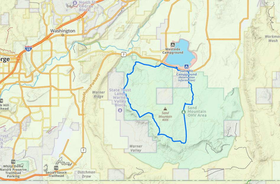
 If you enter via the Sand Hollow State Park take the first right hand turn and proceed to the southern side of the reservoir.
Park in the paved parking lot near the tunnel that allows you to cross under the highway heading south. There is a a restroom in the parking lot.
Park in the paved parking lot near the tunnel that allows you to cross under the highway heading south. There is a a restroom in the parking lot.
OHVsAnything goes. There are no width restrictions.
TerrainCombination of sandstone rock, ledges and sand.
SignageThere are a few location and obstacle signs but the trails are not well marked. Get the GPS tracks.
EmergenciesEmergencies dial 911
Washington County Sheriff (435) 656-6500
620 5300 W, Hurricane, UT 84737
Medical Assistance:
Hurricane Valley Clinic (435) 635-6400
75 N 2260 W, Hurricane, UT 84737
St George Regional Hospital (435) 251-1000
1380 East Medical Center Dr St. George, UT 84790
Washington County Sheriff (435) 656-6500
620 5300 W, Hurricane, UT 84737
Medical Assistance:
Hurricane Valley Clinic (435) 635-6400
75 N 2260 W, Hurricane, UT 84737
St George Regional Hospital (435) 251-1000
1380 East Medical Center Dr St. George, UT 84790
If you enter via the Sand Hollow State Park take the first right hand turn and proceed to the southern side of the reservoir.
Park in the paved parking lot near the tunnel that allows you to cross under the highway heading south. There is a a restroom in the parking lot.
Park in the paved parking lot near the tunnel that allows you to cross under the highway heading south. There is a a restroom in the parking lot.
Anything goes. There are no width restrictions.
Combination of sandstone rock, ledges and sand.
There are a few location and obstacle signs but the trails are not well marked. Get the GPS tracks.
Emergencies dial 911
Washington County Sheriff (435) 656-6500
620 5300 W, Hurricane, UT 84737
Medical Assistance:
Hurricane Valley Clinic (435) 635-6400
75 N 2260 W, Hurricane, UT 84737
St George Regional Hospital (435) 251-1000
1380 East Medical Center Dr St. George, UT 84790
Washington County Sheriff (435) 656-6500
620 5300 W, Hurricane, UT 84737
Medical Assistance:
Hurricane Valley Clinic (435) 635-6400
75 N 2260 W, Hurricane, UT 84737
St George Regional Hospital (435) 251-1000
1380 East Medical Center Dr St. George, UT 84790